You are here: Home > Network List > NN - Western Great Basin/Eastern Sierra Nevada Stations List
> Station MPK Martis Peak, California w84gm > Earthquake Result Viewer
MPK Martis Peak, California w84gm - Earthquake Result Viewer
| Earthquake location: |
Near Coast Of Northern Chile |
| Earthquake latitude/longitude: |
-26.1/-70.6 |
| Earthquake time(UTC): |
2016/07/25 (207) 17:26:49 GMT |
| Earthquake Depth: |
68 km |
| Earthquake Magnitude: |
6.2 MB |
| Earthquake Catalog/Contributor: |
NEIC PDE/NEIC COMCAT |
|
| Network: |
NN Western Great Basin/Eastern Sierra Nevada |
| Station: |
MPK Martis Peak, California w84gm |
| Lat/Lon: |
39.29 N/120.04 W |
| Elevation: |
2599 m |
|
| Distance: |
79.7 deg |
| Az: |
323.225 deg |
| Baz: |
136.077 deg |
| Ray Param: |
0.048615675 |
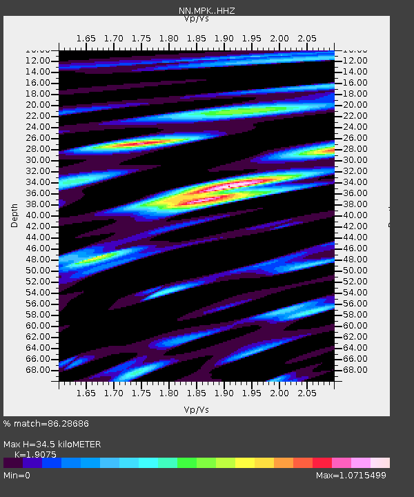
| Estimated Moho Depth: |
34.5 km |
| Estimated Crust Vp/Vs: |
1.91 |
| Assumed Crust Vp: |
6.597 km/s |
| Estimated Crust Vs: |
3.459 km/s |
| Estimated Crust Poisson's Ratio: |
0.31 |
|
| Radial Match: |
86.28686 % |
| Radial Bump: |
400 |
| Transverse Match: |
81.2094 % |
| Transverse Bump: |
400 |
| SOD ConfigId: |
11737051 |
| Insert Time: |
2019-04-25 04:23:00.641 +0000 |
| GWidth: |
2.5 |
| Max Bumps: |
400 |
| Tol: |
0.001 |
|

Signal To Noise
| Channel | StoN | STA | LTA |
| NN:MPK: :HHZ:20160725T17:38:19.698987Z | 11.811806 | 1.4389167E-6 | 1.2182021E-7 |
| NN:MPK: :HHN:20160725T17:38:19.698987Z | 3.2531168 | 3.951752E-7 | 1.2147586E-7 |
| NN:MPK: :HHE:20160725T17:38:19.698987Z | 2.7104547 | 4.442318E-7 | 1.6389568E-7 |
| Arrivals |
| Ps | 4.9 SECOND |
| PpPs | 15 SECOND |
| PsPs/PpSs | 20 SECOND |


