You are here: Home > Network List > NN - Western Great Basin/Eastern Sierra Nevada Stations List
> Station MPK Martis Peak, California w84gm > Earthquake Result Viewer
MPK Martis Peak, California w84gm - Earthquake Result Viewer
| Earthquake location: |
Fiji Islands Region |
| Earthquake latitude/longitude: |
-19.8/-178.3 |
| Earthquake time(UTC): |
2016/09/24 (268) 21:28:42 GMT |
| Earthquake Depth: |
594 km |
| Earthquake Magnitude: |
6.8 MO |
| Earthquake Catalog/Contributor: |
NEIC PDE/NEIC ALERT |
|
| Network: |
NN Western Great Basin/Eastern Sierra Nevada |
| Station: |
MPK Martis Peak, California w84gm |
| Lat/Lon: |
39.29 N/120.04 W |
| Elevation: |
2599 m |
|
| Distance: |
80.1 deg |
| Az: |
42.045 deg |
| Baz: |
234.335 deg |
| Ray Param: |
0.046670344 |
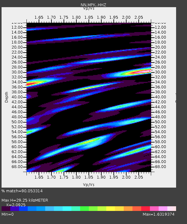
| Estimated Moho Depth: |
29.25 km |
| Estimated Crust Vp/Vs: |
2.09 |
| Assumed Crust Vp: |
6.597 km/s |
| Estimated Crust Vs: |
3.153 km/s |
| Estimated Crust Poisson's Ratio: |
0.35 |
|
| Radial Match: |
90.053314 % |
| Radial Bump: |
400 |
| Transverse Match: |
61.739056 % |
| Transverse Bump: |
400 |
| SOD ConfigId: |
11737051 |
| Insert Time: |
2019-04-25 15:21:24.343 +0000 |
| GWidth: |
2.5 |
| Max Bumps: |
400 |
| Tol: |
0.001 |
|

Signal To Noise
| Channel | StoN | STA | LTA |
| NN:MPK: :HHZ:20160924T21:39:19.208008Z | 15.144534 | 3.3356819E-6 | 2.2025647E-7 |
| NN:MPK: :HHN:20160924T21:39:19.208008Z | 2.9911153 | 1.5695783E-6 | 5.2474684E-7 |
| NN:MPK: :HHE:20160924T21:39:19.208008Z | 3.5744133 | 2.0315251E-6 | 5.6835205E-7 |
| Arrivals |
| Ps | 5.0 SECOND |
| PpPs | 13 SECOND |
| PsPs/PpSs | 18 SECOND |


