You are here: Home > Network List > NN - Western Great Basin/Eastern Sierra Nevada Stations List
> Station MPK Martis Peak, California w84gm > Earthquake Result Viewer
MPK Martis Peak, California w84gm - Earthquake Result Viewer
| Earthquake location: |
Andreanof Islands, Aleutian Is. |
| Earthquake latitude/longitude: |
52.6/-179.5 |
| Earthquake time(UTC): |
2018/02/08 (039) 11:04:01 GMT |
| Earthquake Depth: |
211 km |
| Earthquake Magnitude: |
5.6 Mww |
| Earthquake Catalog/Contributor: |
NEIC PDE/us |
|
| Network: |
NN Western Great Basin/Eastern Sierra Nevada |
| Station: |
MPK Martis Peak, California w84gm |
| Lat/Lon: |
39.29 N/120.04 W |
| Elevation: |
2599 m |
|
| Distance: |
42.2 deg |
| Az: |
83.827 deg |
| Baz: |
308.552 deg |
| Ray Param: |
0.07248554 |
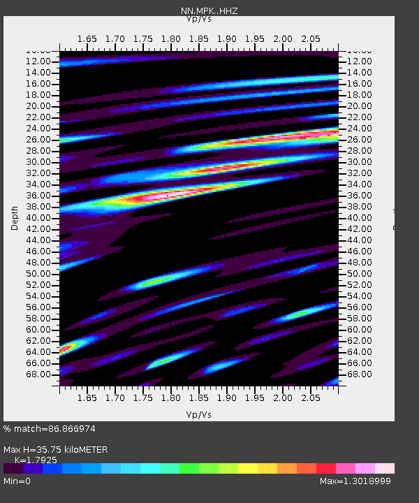
| Estimated Moho Depth: |
35.75 km |
| Estimated Crust Vp/Vs: |
1.79 |
| Assumed Crust Vp: |
6.597 km/s |
| Estimated Crust Vs: |
3.681 km/s |
| Estimated Crust Poisson's Ratio: |
0.27 |
|
| Radial Match: |
86.866974 % |
| Radial Bump: |
400 |
| Transverse Match: |
84.198044 % |
| Transverse Bump: |
400 |
| SOD ConfigId: |
13570011 |
| Insert Time: |
2019-04-29 18:21:35.719 +0000 |
| GWidth: |
2.5 |
| Max Bumps: |
400 |
| Tol: |
0.001 |
|

Signal To Noise
| Channel | StoN | STA | LTA |
| NN:MPK: :HHZ:20180208T11:11:02.918002Z | 49.577934 | 3.2931707E-6 | 6.642412E-8 |
| NN:MPK: :HHN:20180208T11:11:02.918002Z | 17.626972 | 1.2380386E-6 | 7.0235465E-8 |
| NN:MPK: :HHE:20180208T11:11:02.918002Z | 22.662031 | 2.323398E-6 | 1.0252381E-7 |
| Arrivals |
| Ps | 4.6 SECOND |
| PpPs | 14 SECOND |
| PsPs/PpSs | 19 SECOND |


