You are here: Home > Network List > NN - Western Great Basin/Eastern Sierra Nevada Stations List
> Station MPK Martis Peak, California w84gm > Earthquake Result Viewer
MPK Martis Peak, California w84gm - Earthquake Result Viewer
| Earthquake location: |
Northern Chile |
| Earthquake latitude/longitude: |
-19.6/-69.3 |
| Earthquake time(UTC): |
2018/11/01 (305) 22:19:51 GMT |
| Earthquake Depth: |
102 km |
| Earthquake Magnitude: |
6.2 Mww |
| Earthquake Catalog/Contributor: |
NEIC PDE/us |
|
| Network: |
NN Western Great Basin/Eastern Sierra Nevada |
| Station: |
MPK Martis Peak, California w84gm |
| Lat/Lon: |
39.29 N/120.04 W |
| Elevation: |
2599 m |
|
| Distance: |
75.4 deg |
| Az: |
321.608 deg |
| Baz: |
131.013 deg |
| Ray Param: |
0.05148128 |
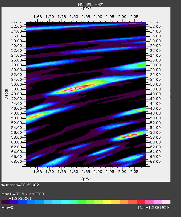
| Estimated Moho Depth: |
37.5 km |
| Estimated Crust Vp/Vs: |
1.81 |
| Assumed Crust Vp: |
6.597 km/s |
| Estimated Crust Vs: |
3.655 km/s |
| Estimated Crust Poisson's Ratio: |
0.28 |
|
| Radial Match: |
88.69682 % |
| Radial Bump: |
400 |
| Transverse Match: |
87.41543 % |
| Transverse Bump: |
400 |
| SOD ConfigId: |
13570011 |
| Insert Time: |
2019-05-01 17:07:36.316 +0000 |
| GWidth: |
2.5 |
| Max Bumps: |
400 |
| Tol: |
0.001 |
|

Signal To Noise
| Channel | StoN | STA | LTA |
| NN:MPK: :HHZ:20181101T22:30:52.928Z | 30.303648 | 2.5096276E-6 | 8.281602E-8 |
| NN:MPK: :HHN:20181101T22:30:52.928Z | 5.813557 | 9.340229E-7 | 1.6066289E-7 |
| NN:MPK: :HHE:20181101T22:30:52.928Z | 4.505448 | 5.944376E-7 | 1.3193753E-7 |
| Arrivals |
| Ps | 4.7 SECOND |
| PpPs | 15 SECOND |
| PsPs/PpSs | 20 SECOND |


