You are here: Home > Network List > NN - Western Great Basin/Eastern Sierra Nevada Stations List
> Station MPK Martis Peak, California w84gm > Earthquake Result Viewer
MPK Martis Peak, California w84gm - Earthquake Result Viewer
| Earthquake location: |
Andreanof Islands, Aleutian Is. |
| Earthquake latitude/longitude: |
51.9/-177.8 |
| Earthquake time(UTC): |
2020/01/23 (023) 05:53:03 GMT |
| Earthquake Depth: |
10 km |
| Earthquake Magnitude: |
6.2 Mw |
| Earthquake Catalog/Contributor: |
NEIC PDE/us |
|
| Network: |
NN Western Great Basin/Eastern Sierra Nevada |
| Station: |
MPK Martis Peak, California w84gm |
| Lat/Lon: |
39.29 N/120.04 W |
| Elevation: |
2599 m |
|
| Distance: |
41.3 deg |
| Az: |
84.269 deg |
| Baz: |
307.428 deg |
| Ray Param: |
0.07388712 |
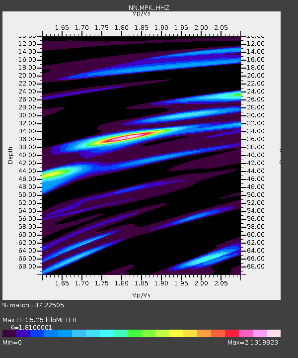
| Estimated Moho Depth: |
35.25 km |
| Estimated Crust Vp/Vs: |
1.81 |
| Assumed Crust Vp: |
6.597 km/s |
| Estimated Crust Vs: |
3.645 km/s |
| Estimated Crust Poisson's Ratio: |
0.28 |
|
| Radial Match: |
87.22505 % |
| Radial Bump: |
400 |
| Transverse Match: |
82.329155 % |
| Transverse Bump: |
400 |
| SOD ConfigId: |
20465011 |
| Insert Time: |
2020-02-06 06:09:33.930 +0000 |
| GWidth: |
2.5 |
| Max Bumps: |
400 |
| Tol: |
0.001 |
|

Signal To Noise
| Channel | StoN | STA | LTA |
| NN:MPK: :HHZ:20200123T06:00:17.958013Z | 11.075088 | 1.7332604E-6 | 1.5650083E-7 |
| NN:MPK: :HHN:20200123T06:00:17.958013Z | 2.7399986 | 5.440369E-7 | 1.985537E-7 |
| NN:MPK: :HHE:20200123T06:00:17.958013Z | 3.1766012 | 8.861904E-7 | 2.789744E-7 |
| Arrivals |
| Ps | 4.6 SECOND |
| PpPs | 14 SECOND |
| PsPs/PpSs | 19 SECOND |


