You are here: Home > Network List > NN - Western Great Basin/Eastern Sierra Nevada Stations List
> Station MPK Martis Peak, California w84gm > Earthquake Result Viewer
MPK Martis Peak, California w84gm - Earthquake Result Viewer
| Earthquake location: |
Near Coast Of Oaxaca, Mexico |
| Earthquake latitude/longitude: |
15.6/-95.9 |
| Earthquake time(UTC): |
2020/07/24 (206) 03:19:51 GMT |
| Earthquake Depth: |
6.6 km |
| Earthquake Magnitude: |
5.5 mww |
| Earthquake Catalog/Contributor: |
NEIC PDE/us |
|
| Network: |
NN Western Great Basin/Eastern Sierra Nevada |
| Station: |
MPK Martis Peak, California w84gm |
| Lat/Lon: |
39.29 N/120.04 W |
| Elevation: |
2599 m |
|
| Distance: |
31.7 deg |
| Az: |
322.799 deg |
| Baz: |
131.346 deg |
| Ray Param: |
0.07899105 |
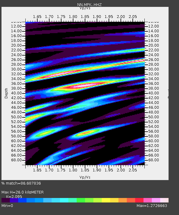
| Estimated Moho Depth: |
26.0 km |
| Estimated Crust Vp/Vs: |
2.10 |
| Assumed Crust Vp: |
6.597 km/s |
| Estimated Crust Vs: |
3.149 km/s |
| Estimated Crust Poisson's Ratio: |
0.35 |
|
| Radial Match: |
86.687836 % |
| Radial Bump: |
400 |
| Transverse Match: |
60.813583 % |
| Transverse Bump: |
400 |
| SOD ConfigId: |
21709731 |
| Insert Time: |
2020-08-07 03:34:50.491 +0000 |
| GWidth: |
2.5 |
| Max Bumps: |
400 |
| Tol: |
0.001 |
|

Signal To Noise
| Channel | StoN | STA | LTA |
| NN:MPK: :HHZ:20200724T03:25:44.357996Z | 5.0594993 | 6.142991E-7 | 1.21415E-7 |
| NN:MPK: :HHN:20200724T03:25:44.357996Z | 1.890725 | 3.4006956E-7 | 1.7986198E-7 |
| NN:MPK: :HHE:20200724T03:25:44.357996Z | 2.069311 | 4.133504E-7 | 1.9975269E-7 |
| Arrivals |
| Ps | 4.6 SECOND |
| PpPs | 11 SECOND |
| PsPs/PpSs | 16 SECOND |


