You are here: Home > Network List > NN - Western Great Basin/Eastern Sierra Nevada Stations List
> Station MPK Martis Peak, California w84gm > Earthquake Result Viewer
MPK Martis Peak, California w84gm - Earthquake Result Viewer
| Earthquake location: |
South Of Alaska |
| Earthquake latitude/longitude: |
54.7/-159.6 |
| Earthquake time(UTC): |
2020/10/19 (293) 20:54:40 GMT |
| Earthquake Depth: |
41 km |
| Earthquake Magnitude: |
7.4 Mi |
| Earthquake Catalog/Contributor: |
NEIC PDE/at |
|
| Network: |
NN Western Great Basin/Eastern Sierra Nevada |
| Station: |
MPK Martis Peak, California w84gm |
| Lat/Lon: |
39.29 N/120.04 W |
| Elevation: |
2599 m |
|
| Distance: |
30.6 deg |
| Az: |
103.694 deg |
| Baz: |
313.335 deg |
| Ray Param: |
0.07932006 |
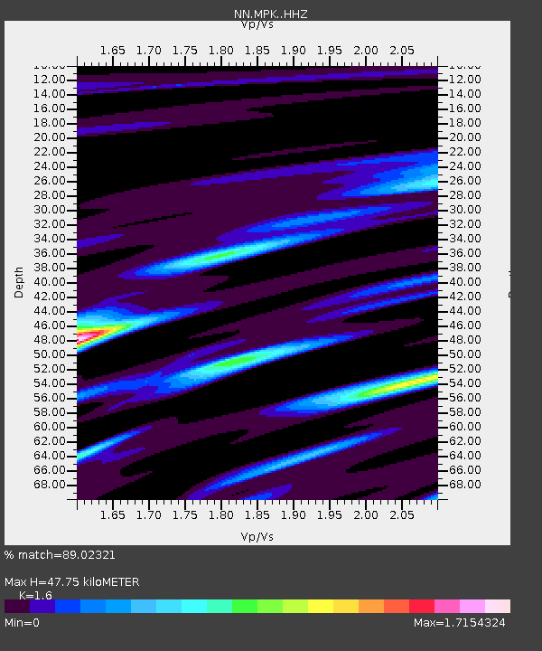
| Estimated Moho Depth: |
47.75 km |
| Estimated Crust Vp/Vs: |
1.60 |
| Assumed Crust Vp: |
6.597 km/s |
| Estimated Crust Vs: |
4.123 km/s |
| Estimated Crust Poisson's Ratio: |
0.18 |
|
| Radial Match: |
89.02321 % |
| Radial Bump: |
400 |
| Transverse Match: |
80.16547 % |
| Transverse Bump: |
400 |
| SOD ConfigId: |
22732711 |
| Insert Time: |
2020-11-02 21:13:21.397 +0000 |
| GWidth: |
2.5 |
| Max Bumps: |
400 |
| Tol: |
0.001 |
|

Signal To Noise
| Channel | StoN | STA | LTA |
| NN:MPK: :HHZ:20201019T21:00:19.708008Z | 6.049533 | 8.44848E-7 | 1.3965509E-7 |
| NN:MPK: :HHN:20201019T21:00:19.708008Z | 1.7882836 | 3.1934778E-7 | 1.7857782E-7 |
| NN:MPK: :HHE:20201019T21:00:19.708008Z | 2.906761 | 3.7850626E-7 | 1.3021582E-7 |
| Arrivals |
| Ps | 4.8 SECOND |
| PpPs | 17 SECOND |
| PsPs/PpSs | 22 SECOND |


