You are here: Home > Network List > NN - Western Great Basin/Eastern Sierra Nevada Stations List
> Station MPK Martis Peak, California w84gm > Earthquake Result Viewer
MPK Martis Peak, California w84gm - Earthquake Result Viewer
| Earthquake location: |
Kermadec Islands, New Zealand |
| Earthquake latitude/longitude: |
-30.2/-177.8 |
| Earthquake time(UTC): |
2021/06/20 (171) 17:05:48 GMT |
| Earthquake Depth: |
10 km |
| Earthquake Magnitude: |
6.5 mww |
| Earthquake Catalog/Contributor: |
NEIC PDE/us |
|
| Network: |
NN Western Great Basin/Eastern Sierra Nevada |
| Station: |
MPK Martis Peak, California w84gm |
| Lat/Lon: |
39.29 N/120.04 W |
| Elevation: |
2599 m |
|
| Distance: |
87.6 deg |
| Az: |
41.076 deg |
| Baz: |
227.135 deg |
| Ray Param: |
0.04323242 |
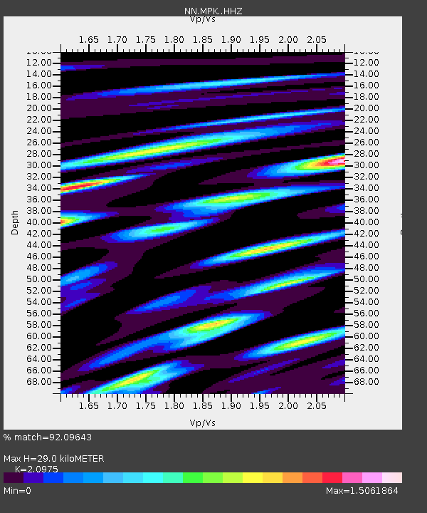
| Estimated Moho Depth: |
29.0 km |
| Estimated Crust Vp/Vs: |
2.10 |
| Assumed Crust Vp: |
6.597 km/s |
| Estimated Crust Vs: |
3.145 km/s |
| Estimated Crust Poisson's Ratio: |
0.35 |
|
| Radial Match: |
92.09643 % |
| Radial Bump: |
400 |
| Transverse Match: |
74.90432 % |
| Transverse Bump: |
400 |
| SOD ConfigId: |
25131211 |
| Insert Time: |
2021-07-04 17:24:47.318 +0000 |
| GWidth: |
2.5 |
| Max Bumps: |
400 |
| Tol: |
0.001 |
|

Signal To Noise
| Channel | StoN | STA | LTA |
| NN:MPK: :HHZ:20210620T17:18:04.717975Z | 16.568848 | 1.8366627E-6 | 1.1085036E-7 |
| NN:MPK: :HHN:20210620T17:18:04.717975Z | 2.8972688 | 6.2895015E-7 | 2.1708381E-7 |
| NN:MPK: :HHE:20210620T17:18:04.717975Z | 3.822702 | 5.9076035E-7 | 1.5453999E-7 |
| Arrivals |
| Ps | 4.9 SECOND |
| PpPs | 13 SECOND |
| PsPs/PpSs | 18 SECOND |


