You are here: Home > Network List > NN - Western Great Basin/Eastern Sierra Nevada Stations List
> Station MPK Martis Peak, California w84gm > Earthquake Result Viewer
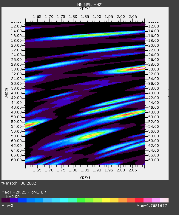
MPK Martis Peak, California w84gm - Earthquake Result Viewer
| Earthquake location: |
Vanuatu Islands Region |
| Earthquake latitude/longitude: |
-21.2/174.5 |
| Earthquake time(UTC): |
2021/10/09 (282) 10:58:30 GMT |
| Earthquake Depth: |
520 km |
| Earthquake Magnitude: |
6.9 mww |
| Earthquake Catalog/Contributor: |
NEIC PDE/us |
|
| Network: |
NN Western Great Basin/Eastern Sierra Nevada |
| Station: |
MPK Martis Peak, California w84gm |
| Lat/Lon: |
39.29 N/120.04 W |
| Elevation: |
2599 m |
|
| Distance: |
85.7 deg |
| Az: |
45.051 deg |
| Baz: |
238.344 deg |
| Ray Param: |
0.043110397 |
| Estimated Moho Depth: |
29.25 km |
| Estimated Crust Vp/Vs: |
2.09 |
| Assumed Crust Vp: |
6.597 km/s |
| Estimated Crust Vs: |
3.157 km/s |
| Estimated Crust Poisson's Ratio: |
0.35 |
|
| Radial Match: |
86.2602 % |
| Radial Bump: |
400 |
| Transverse Match: |
79.65677 % |
| Transverse Bump: |
400 |
| SOD ConfigId: |
26497111 |
| Insert Time: |
2021-10-23 11:16:22.249 +0000 |
| GWidth: |
2.5 |
| Max Bumps: |
400 |
| Tol: |
0.001 |
|

Signal To Noise
| Channel | StoN | STA | LTA |
| NN:MPK: :HHZ:20211009T11:09:43.297984Z | 5.1531663 | 5.8417606E-7 | 1.1336254E-7 |
| NN:MPK: :HHN:20211009T11:09:43.297984Z | 1.3752306 | 2.0520616E-7 | 1.4921584E-7 |
| NN:MPK: :HHE:20211009T11:09:43.297984Z | 1.3488159 | 2.9728E-7 | 2.2040071E-7 |
| Arrivals |
| Ps | 4.9 SECOND |
| PpPs | 13 SECOND |
| PsPs/PpSs | 18 SECOND |


