You are here: Home > Network List > NN - Western Great Basin/Eastern Sierra Nevada Stations List
> Station MPK Martis Peak, California w84gm > Earthquake Result Viewer
MPK Martis Peak, California w84gm - Earthquake Result Viewer
| Earthquake location: |
Kermadec Islands, New Zealand |
| Earthquake latitude/longitude: |
-30.1/-177.7 |
| Earthquake time(UTC): |
2022/03/02 (061) 12:52:07 GMT |
| Earthquake Depth: |
24 km |
| Earthquake Magnitude: |
6.6 mww |
| Earthquake Catalog/Contributor: |
NEIC PDE/us |
|
| Network: |
NN Western Great Basin/Eastern Sierra Nevada |
| Station: |
MPK Martis Peak, California w84gm |
| Lat/Lon: |
39.29 N/120.04 W |
| Elevation: |
2599 m |
|
| Distance: |
87.4 deg |
| Az: |
41.035 deg |
| Baz: |
227.169 deg |
| Ray Param: |
0.04331538 |
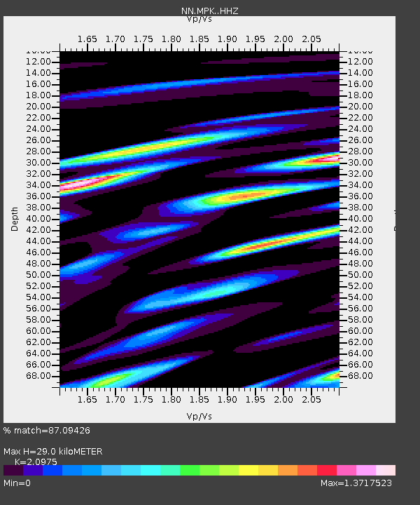
| Estimated Moho Depth: |
29.0 km |
| Estimated Crust Vp/Vs: |
2.10 |
| Assumed Crust Vp: |
6.597 km/s |
| Estimated Crust Vs: |
3.145 km/s |
| Estimated Crust Poisson's Ratio: |
0.35 |
|
| Radial Match: |
87.09426 % |
| Radial Bump: |
400 |
| Transverse Match: |
83.1077 % |
| Transverse Bump: |
400 |
| SOD ConfigId: |
26694651 |
| Insert Time: |
2022-03-16 13:10:24.618 +0000 |
| GWidth: |
2.5 |
| Max Bumps: |
400 |
| Tol: |
0.001 |
|

Signal To Noise
| Channel | StoN | STA | LTA |
| NN:MPK: :HHZ:20220302T13:04:21.108015Z | 3.1246638 | 8.246645E-7 | 2.6392104E-7 |
| NN:MPK: :HHN:20220302T13:04:21.108015Z | 1.1641098 | 3.7161104E-7 | 3.1922337E-7 |
| NN:MPK: :HHE:20220302T13:04:21.108015Z | 1.3342383 | 3.5301983E-7 | 2.645853E-7 |
| Arrivals |
| Ps | 4.9 SECOND |
| PpPs | 13 SECOND |
| PsPs/PpSs | 18 SECOND |


