You are here: Home > Network List > NN - Western Great Basin/Eastern Sierra Nevada Stations List
> Station MPK Martis Peak, California w84gm > Earthquake Result Viewer
MPK Martis Peak, California w84gm - Earthquake Result Viewer
| Earthquake location: |
Northern Chile |
| Earthquake latitude/longitude: |
-22.2/-68.5 |
| Earthquake time(UTC): |
2022/07/27 (208) 18:58:57 GMT |
| Earthquake Depth: |
97 km |
| Earthquake Magnitude: |
6.2 Mww |
| Earthquake Catalog/Contributor: |
NEIC PDE/us |
|
| Network: |
NN Western Great Basin/Eastern Sierra Nevada |
| Station: |
MPK Martis Peak, California w84gm |
| Lat/Lon: |
39.29 N/120.04 W |
| Elevation: |
2599 m |
|
| Distance: |
77.9 deg |
| Az: |
321.571 deg |
| Baz: |
132.072 deg |
| Ray Param: |
0.049829356 |
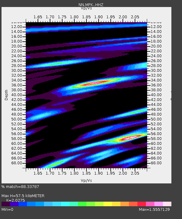
| Estimated Moho Depth: |
57.5 km |
| Estimated Crust Vp/Vs: |
2.03 |
| Assumed Crust Vp: |
6.597 km/s |
| Estimated Crust Vs: |
3.254 km/s |
| Estimated Crust Poisson's Ratio: |
0.34 |
|
| Radial Match: |
88.33787 % |
| Radial Bump: |
400 |
| Transverse Match: |
73.18934 % |
| Transverse Bump: |
400 |
| SOD ConfigId: |
28764291 |
| Insert Time: |
2022-08-10 19:29:20.792 +0000 |
| GWidth: |
2.5 |
| Max Bumps: |
400 |
| Tol: |
0.001 |
|

Signal To Noise
| Channel | StoN | STA | LTA |
| NN:MPK: :HHZ:20220727T19:10:13.59799Z | 8.702308 | 7.4080606E-7 | 8.512754E-8 |
| NN:MPK: :HHN:20220727T19:10:13.59799Z | 1.0017617 | 1.9128572E-7 | 1.9094934E-7 |
| NN:MPK: :HHE:20220727T19:10:13.59799Z | 1.8314444 | 2.7961119E-7 | 1.526725E-7 |
| Arrivals |
| Ps | 9.2 SECOND |
| PpPs | 26 SECOND |
| PsPs/PpSs | 35 SECOND |


