You are here: Home > Network List > NN - Western Great Basin/Eastern Sierra Nevada Stations List
> Station MPK Martis Peak, California w84gm > Earthquake Result Viewer
MPK Martis Peak, California w84gm - Earthquake Result Viewer
| Earthquake location: |
Near Coast Of Chiapas, Mexico |
| Earthquake latitude/longitude: |
15.0/-93.9 |
| Earthquake time(UTC): |
2023/07/14 (195) 09:29:01 GMT |
| Earthquake Depth: |
35 km |
| Earthquake Magnitude: |
6.3 mww |
| Earthquake Catalog/Contributor: |
NEIC PDE/us |
|
| Network: |
NN Western Great Basin/Eastern Sierra Nevada |
| Station: |
MPK Martis Peak, California w84gm |
| Lat/Lon: |
39.29 N/120.04 W |
| Elevation: |
2599 m |
|
| Distance: |
33.3 deg |
| Az: |
321.486 deg |
| Baz: |
129.164 deg |
| Ray Param: |
0.0782168 |
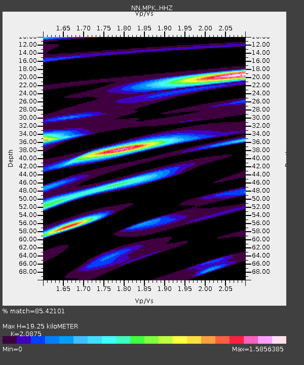
| Estimated Moho Depth: |
19.25 km |
| Estimated Crust Vp/Vs: |
2.09 |
| Assumed Crust Vp: |
6.597 km/s |
| Estimated Crust Vs: |
3.16 km/s |
| Estimated Crust Poisson's Ratio: |
0.35 |
|
| Radial Match: |
85.42101 % |
| Radial Bump: |
400 |
| Transverse Match: |
75.3895 % |
| Transverse Bump: |
400 |
| SOD ConfigId: |
30536071 |
| Insert Time: |
2023-07-28 09:54:37.780 +0000 |
| GWidth: |
2.5 |
| Max Bumps: |
400 |
| Tol: |
0.001 |
|

Signal To Noise
| Channel | StoN | STA | LTA |
| NN:MPK: :HHZ:20230714T09:35:05.628005Z | 28.667896 | 1.6996264E-6 | 5.928675E-8 |
| NN:MPK: :HHN:20230714T09:35:05.628005Z | 9.539286 | 5.7238486E-7 | 6.0002904E-8 |
| NN:MPK: :HHE:20230714T09:35:05.628005Z | 10.813087 | 8.380382E-7 | 7.7502214E-8 |
| Arrivals |
| Ps | 3.4 SECOND |
| PpPs | 8.4 SECOND |
| PsPs/PpSs | 12 SECOND |


