You are here: Home > Network List > NN - Western Great Basin/Eastern Sierra Nevada Stations List
> Station MPK Martis Peak, California w84gm > Earthquake Result Viewer
MPK Martis Peak, California w84gm - Earthquake Result Viewer
| Earthquake location: |
Tonga Islands |
| Earthquake latitude/longitude: |
-18.7/-175.5 |
| Earthquake time(UTC): |
2023/12/11 (345) 06:33:31 GMT |
| Earthquake Depth: |
238 km |
| Earthquake Magnitude: |
6.1 Mww |
| Earthquake Catalog/Contributor: |
NEIC PDE/us |
|
| Network: |
NN Western Great Basin/Eastern Sierra Nevada |
| Station: |
MPK Martis Peak, California w84gm |
| Lat/Lon: |
39.29 N/120.04 W |
| Elevation: |
2599 m |
|
| Distance: |
77.5 deg |
| Az: |
40.892 deg |
| Baz: |
233.104 deg |
| Ray Param: |
0.04965814 |
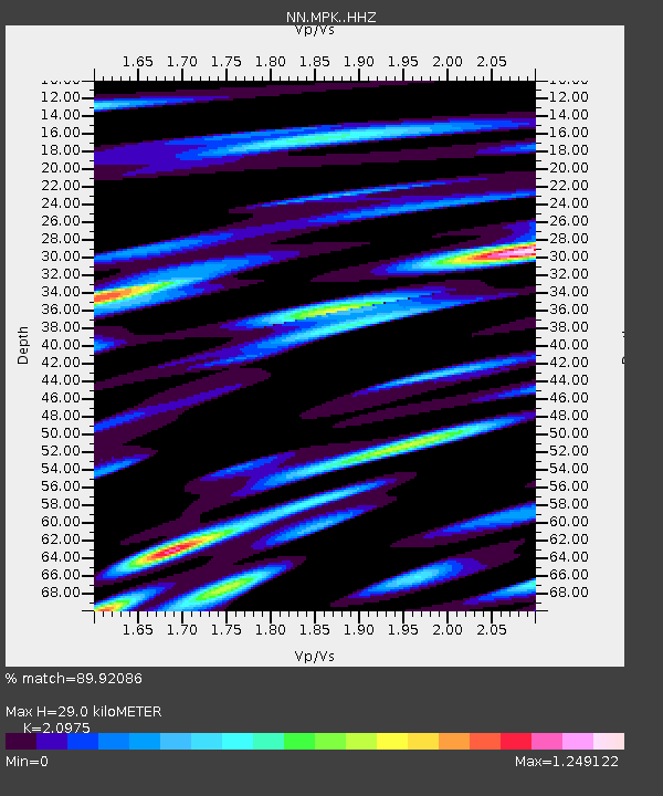
| Estimated Moho Depth: |
29.0 km |
| Estimated Crust Vp/Vs: |
2.10 |
| Assumed Crust Vp: |
6.597 km/s |
| Estimated Crust Vs: |
3.145 km/s |
| Estimated Crust Poisson's Ratio: |
0.35 |
|
| Radial Match: |
89.92086 % |
| Radial Bump: |
400 |
| Transverse Match: |
86.66869 % |
| Transverse Bump: |
400 |
| SOD ConfigId: |
33232451 |
| Insert Time: |
2023-12-25 06:57:40.383 +0000 |
| GWidth: |
2.5 |
| Max Bumps: |
400 |
| Tol: |
0.001 |
|

Signal To Noise
| Channel | StoN | STA | LTA |
| NN:MPK: :HHZ:20231211T06:44:29.128022Z | 5.5637784 | 1.2676313E-6 | 2.2783641E-7 |
| NN:MPK: :HHN:20231211T06:44:29.128022Z | 2.0453367 | 4.171497E-7 | 2.039516E-7 |
| NN:MPK: :HHE:20231211T06:44:29.128022Z | 2.4184463 | 5.967821E-7 | 2.467626E-7 |
| Arrivals |
| Ps | 5.0 SECOND |
| PpPs | 13 SECOND |
| PsPs/PpSs | 18 SECOND |


