You are here: Home > Network List > NN - Western Great Basin/Eastern Sierra Nevada Stations List
> Station MPK Martis Peak, California w84gm > Earthquake Result Viewer
MPK Martis Peak, California w84gm - Earthquake Result Viewer
| Earthquake location: |
Shikoku, Japan |
| Earthquake latitude/longitude: |
33.2/132.4 |
| Earthquake time(UTC): |
2024/04/17 (108) 14:14:45 GMT |
| Earthquake Depth: |
26 km |
| Earthquake Magnitude: |
6.3 mww |
| Earthquake Catalog/Contributor: |
NEIC PDE/us |
|
| Network: |
NN Western Great Basin/Eastern Sierra Nevada |
| Station: |
MPK Martis Peak, California w84gm |
| Lat/Lon: |
39.29 N/120.04 W |
| Elevation: |
2599 m |
|
| Distance: |
81.6 deg |
| Az: |
48.407 deg |
| Baz: |
306.06 deg |
| Ray Param: |
0.047479633 |
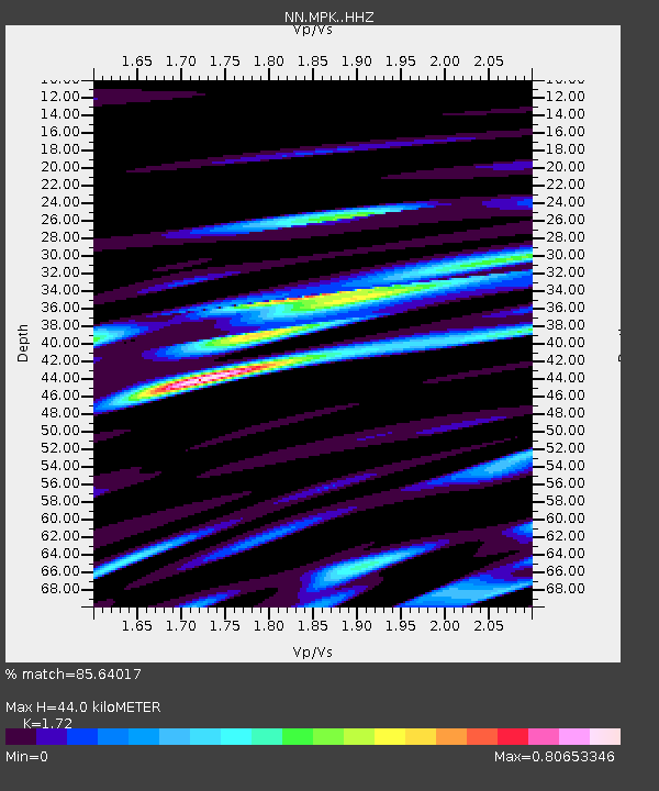
| Estimated Moho Depth: |
44.0 km |
| Estimated Crust Vp/Vs: |
1.72 |
| Assumed Crust Vp: |
6.597 km/s |
| Estimated Crust Vs: |
3.836 km/s |
| Estimated Crust Poisson's Ratio: |
0.24 |
|
| Radial Match: |
85.64017 % |
| Radial Bump: |
400 |
| Transverse Match: |
79.212234 % |
| Transverse Bump: |
400 |
| SOD ConfigId: |
34243671 |
| Insert Time: |
2024-05-09 01:57:55.727 +0000 |
| GWidth: |
2.5 |
| Max Bumps: |
400 |
| Tol: |
0.001 |
|

Signal To Noise
| Channel | StoN | STA | LTA |
| NN:MPK: :HHZ:20240417T14:26:29.608015Z | 14.24916 | 2.0397554E-6 | 1.4314917E-7 |
| NN:MPK: :HHN:20240417T14:26:29.608015Z | 2.9021573 | 3.7061417E-7 | 1.27703E-7 |
| NN:MPK: :HHE:20240417T14:26:29.608015Z | 4.8724823 | 7.7266515E-7 | 1.5857732E-7 |
| Arrivals |
| Ps | 4.9 SECOND |
| PpPs | 18 SECOND |
| PsPs/PpSs | 23 SECOND |


