You are here: Home > Network List > NN - Western Great Basin/Eastern Sierra Nevada Stations List
> Station MPK Martis Peak, California w84gm > Earthquake Result Viewer
MPK Martis Peak, California w84gm - Earthquake Result Viewer
| Earthquake location: |
Near Coast Of Chiapas, Mexico |
| Earthquake latitude/longitude: |
14.5/-92.4 |
| Earthquake time(UTC): |
2024/05/12 (133) 11:39:14 GMT |
| Earthquake Depth: |
75 km |
| Earthquake Magnitude: |
6.4 mww |
| Earthquake Catalog/Contributor: |
NEIC PDE/us |
|
| Network: |
NN Western Great Basin/Eastern Sierra Nevada |
| Station: |
MPK Martis Peak, California w84gm |
| Lat/Lon: |
39.29 N/120.04 W |
| Elevation: |
2599 m |
|
| Distance: |
34.7 deg |
| Az: |
320.718 deg |
| Baz: |
127.776 deg |
| Ray Param: |
0.07739688 |
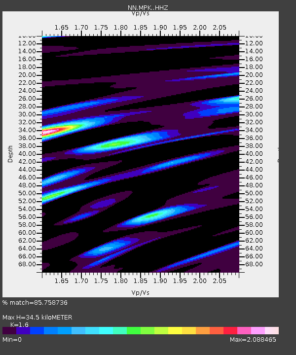
| Estimated Moho Depth: |
34.5 km |
| Estimated Crust Vp/Vs: |
1.60 |
| Assumed Crust Vp: |
6.597 km/s |
| Estimated Crust Vs: |
4.123 km/s |
| Estimated Crust Poisson's Ratio: |
0.18 |
|
| Radial Match: |
85.758736 % |
| Radial Bump: |
400 |
| Transverse Match: |
76.27393 % |
| Transverse Bump: |
400 |
| SOD ConfigId: |
34924831 |
| Insert Time: |
2024-05-28 19:48:30.618 +0000 |
| GWidth: |
2.5 |
| Max Bumps: |
400 |
| Tol: |
0.001 |
|

Signal To Noise
| Channel | StoN | STA | LTA |
| NN:MPK: :HHZ:20240512T11:45:26.377997Z | 15.53091 | 1.539262E-6 | 9.9109585E-8 |
| NN:MPK: :HHN:20240512T11:45:26.377997Z | 6.6465635 | 8.002794E-7 | 1.2040499E-7 |
| NN:MPK: :HHE:20240512T11:45:26.377997Z | 5.1297855 | 7.430498E-7 | 1.4485008E-7 |
| Arrivals |
| Ps | 3.4 SECOND |
| PpPs | 12 SECOND |
| PsPs/PpSs | 16 SECOND |


