You are here: Home > Network List > NN - Western Great Basin/Eastern Sierra Nevada Stations List
> Station MPK Martis Peak, California w84gm > Earthquake Result Viewer
MPK Martis Peak, California w84gm - Earthquake Result Viewer
| Earthquake location: |
Near West Coast Of Honshu, Japan |
| Earthquake latitude/longitude: |
37.5/137.2 |
| Earthquake time(UTC): |
2024/06/02 (154) 21:31:38 GMT |
| Earthquake Depth: |
4.8 km |
| Earthquake Magnitude: |
5.8 mww |
| Earthquake Catalog/Contributor: |
NEIC PDE/us |
|
| Network: |
NN Western Great Basin/Eastern Sierra Nevada |
| Station: |
MPK Martis Peak, California w84gm |
| Lat/Lon: |
39.29 N/120.04 W |
| Elevation: |
2599 m |
|
| Distance: |
75.8 deg |
| Az: |
51.346 deg |
| Baz: |
306.791 deg |
| Ray Param: |
0.051467333 |
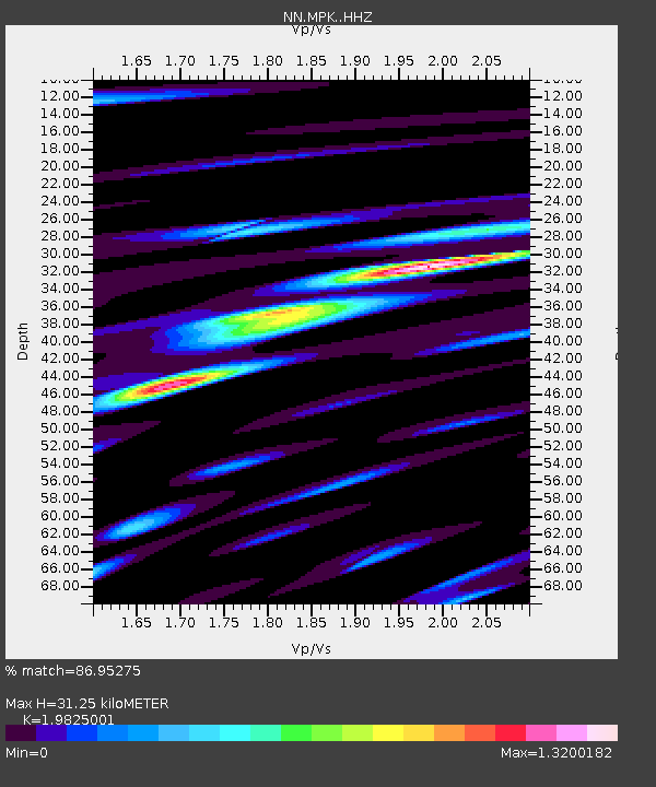
| Estimated Moho Depth: |
31.25 km |
| Estimated Crust Vp/Vs: |
1.98 |
| Assumed Crust Vp: |
6.597 km/s |
| Estimated Crust Vs: |
3.328 km/s |
| Estimated Crust Poisson's Ratio: |
0.33 |
|
| Radial Match: |
86.95275 % |
| Radial Bump: |
400 |
| Transverse Match: |
80.7978 % |
| Transverse Bump: |
400 |
| SOD ConfigId: |
35001331 |
| Insert Time: |
2024-06-16 22:02:18.064 +0000 |
| GWidth: |
2.5 |
| Max Bumps: |
400 |
| Tol: |
0.001 |
|

Signal To Noise
| Channel | StoN | STA | LTA |
| NN:MPK: :HHZ:20240602T21:42:53.838009Z | 20.67686 | 1.8137108E-6 | 8.771693E-8 |
| NN:MPK: :HHN:20240602T21:42:53.838009Z | 2.2879946 | 3.7296698E-7 | 1.6301044E-7 |
| NN:MPK: :HHE:20240602T21:42:53.838009Z | 4.352637 | 7.4334264E-7 | 1.7077984E-7 |
| Arrivals |
| Ps | 4.8 SECOND |
| PpPs | 14 SECOND |
| PsPs/PpSs | 19 SECOND |


