You are here: Home > Network List > NN - Western Great Basin/Eastern Sierra Nevada Stations List
> Station MPK Martis Peak, California w84gm > Earthquake Result Viewer
MPK Martis Peak, California w84gm - Earthquake Result Viewer
| Earthquake location: |
Off East Coast Of Honshu, Japan |
| Earthquake latitude/longitude: |
39.8/143.6 |
| Earthquake time(UTC): |
2015/02/20 (051) 04:25:24 GMT |
| Earthquake Depth: |
14 km |
| Earthquake Magnitude: |
6.3 MWP |
| Earthquake Catalog/Contributor: |
NEIC PDE/NEIC COMCAT |
|
| Network: |
NN Western Great Basin/Eastern Sierra Nevada |
| Station: |
MPK Martis Peak, California w84gm |
| Lat/Lon: |
39.29 N/120.04 W |
| Elevation: |
2599 m |
|
| Distance: |
70.4 deg |
| Az: |
54.962 deg |
| Baz: |
305.678 deg |
| Ray Param: |
0.055023234 |
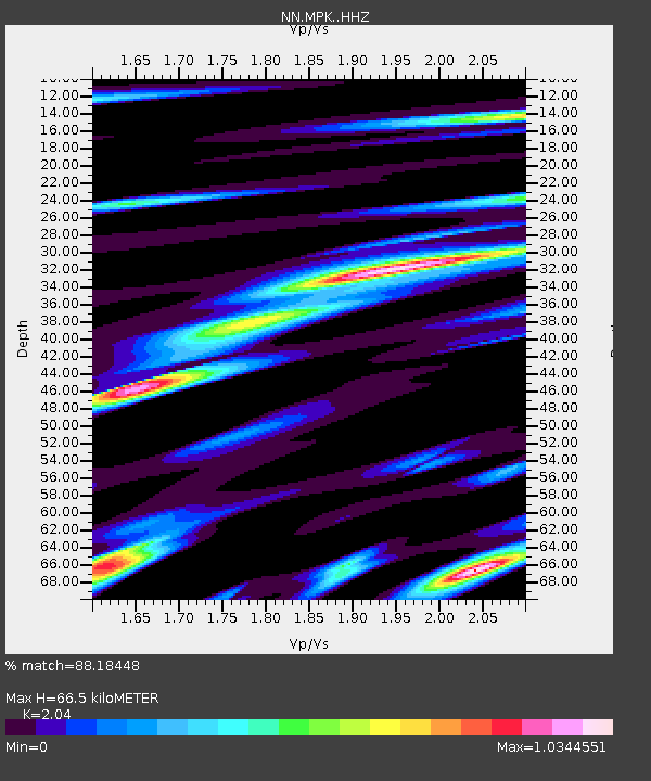
| Estimated Moho Depth: |
66.5 km |
| Estimated Crust Vp/Vs: |
2.04 |
| Assumed Crust Vp: |
6.597 km/s |
| Estimated Crust Vs: |
3.234 km/s |
| Estimated Crust Poisson's Ratio: |
0.34 |
|
| Radial Match: |
88.18448 % |
| Radial Bump: |
400 |
| Transverse Match: |
75.72001 % |
| Transverse Bump: |
400 |
| SOD ConfigId: |
7019011 |
| Insert Time: |
2019-04-16 23:27:09.196 +0000 |
| GWidth: |
2.5 |
| Max Bumps: |
400 |
| Tol: |
0.001 |
|

Signal To Noise
| Channel | StoN | STA | LTA |
| NN:MPK: :HHZ:20150220T04:36:05.877993Z | 4.676968 | 5.1996045E-7 | 1.11174685E-7 |
| NN:MPK: :HHN:20150220T04:36:05.877993Z | 0.9620226 | 1.1540985E-7 | 1.1996583E-7 |
| NN:MPK: :HHE:20150220T04:36:05.877993Z | 1.4810659 | 2.38106E-7 | 1.6076666E-7 |
| Arrivals |
| Ps | 11 SECOND |
| PpPs | 30 SECOND |
| PsPs/PpSs | 40 SECOND |


