You are here: Home > Network List > NN - Western Great Basin/Eastern Sierra Nevada Stations List
> Station MPK Martis Peak, California w84gm > Earthquake Result Viewer
MPK Martis Peak, California w84gm - Earthquake Result Viewer
| Earthquake location: |
Solomon Islands |
| Earthquake latitude/longitude: |
-7.5/154.8 |
| Earthquake time(UTC): |
2015/05/07 (127) 08:50:57 GMT |
| Earthquake Depth: |
31 km |
| Earthquake Magnitude: |
4.9 mb |
| Earthquake Catalog/Contributor: |
ISC/ISC |
|
| Network: |
NN Western Great Basin/Eastern Sierra Nevada |
| Station: |
MPK Martis Peak, California w84gm |
| Lat/Lon: |
39.29 N/120.04 W |
| Elevation: |
2599 m |
|
| Distance: |
91.0 deg |
| Az: |
50.657 deg |
| Baz: |
261.203 deg |
| Ray Param: |
0.04163209 |
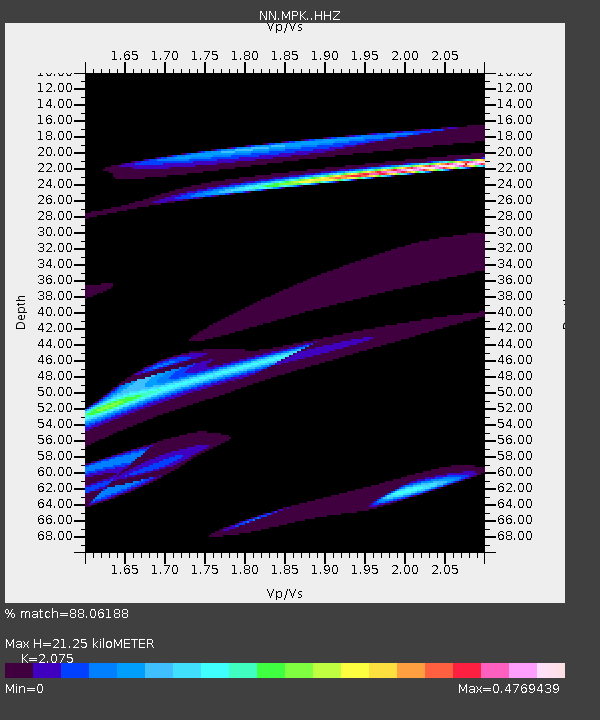
| Estimated Moho Depth: |
21.25 km |
| Estimated Crust Vp/Vs: |
2.08 |
| Assumed Crust Vp: |
6.597 km/s |
| Estimated Crust Vs: |
3.18 km/s |
| Estimated Crust Poisson's Ratio: |
0.35 |
|
| Radial Match: |
88.06188 % |
| Radial Bump: |
400 |
| Transverse Match: |
90.88226 % |
| Transverse Bump: |
400 |
| SOD ConfigId: |
7422571 |
| Insert Time: |
2019-04-18 17:44:24.671 +0000 |
| GWidth: |
2.5 |
| Max Bumps: |
400 |
| Tol: |
0.001 |
|

Signal To Noise
| Channel | StoN | STA | LTA |
| NN:MPK: :HHZ:20150507T09:03:26.587983Z | 0.93813205 | 5.7281653E-7 | 6.105926E-7 |
| NN:MPK: :HHN:20150507T09:03:26.587983Z | 1.936144 | 1.1638379E-6 | 6.0111125E-7 |
| NN:MPK: :HHE:20150507T09:03:26.587983Z | 0.7405187 | 1.0550879E-6 | 1.4247956E-6 |
| Arrivals |
| Ps | 3.5 SECOND |
| PpPs | 9.7 SECOND |
| PsPs/PpSs | 13 SECOND |


