You are here: Home > Network List > PY - PFO Array Stations List
> Station BPH02 Pinon Flat Observatory, CA, USA > Earthquake Result Viewer
BPH02 Pinon Flat Observatory, CA, USA - Earthquake Result Viewer
| Earthquake location: |
Southeast Of Loyalty Islands |
| Earthquake latitude/longitude: |
-22.5/173.1 |
| Earthquake time(UTC): |
2016/08/12 (225) 01:26:35 GMT |
| Earthquake Depth: |
10 km |
| Earthquake Magnitude: |
7.2 MWW, 7.6 MI |
| Earthquake Catalog/Contributor: |
NEIC PDE/NEIC COMCAT |
|
| Network: |
PY PFO Array |
| Station: |
BPH02 Pinon Flat Observatory, CA, USA |
| Lat/Lon: |
33.61 N/116.46 W |
| Elevation: |
1289 m |
|
| Distance: |
87.2 deg |
| Az: |
51.932 deg |
| Baz: |
240.745 deg |
| Ray Param: |
0.043495614 |
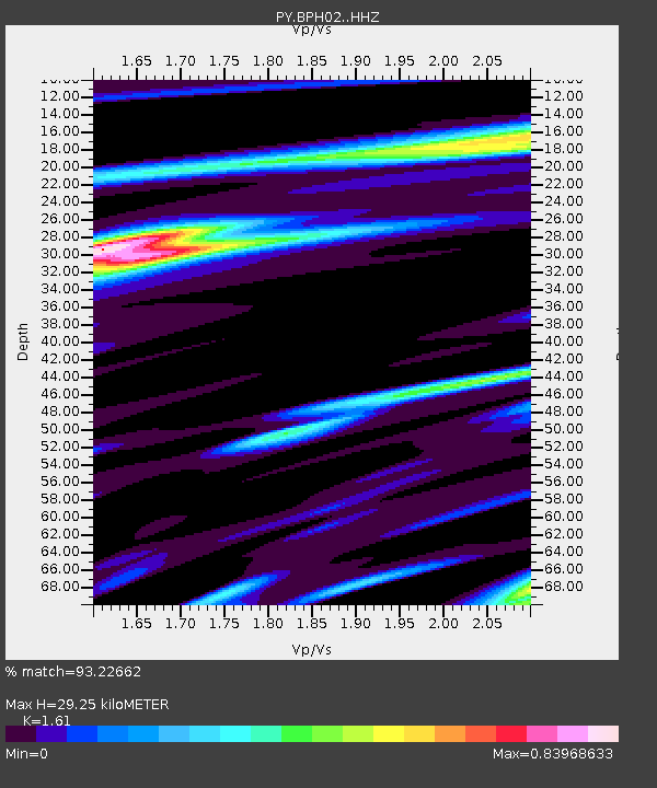
| Estimated Moho Depth: |
29.25 km |
| Estimated Crust Vp/Vs: |
1.61 |
| Assumed Crust Vp: |
6.264 km/s |
| Estimated Crust Vs: |
3.89 km/s |
| Estimated Crust Poisson's Ratio: |
0.19 |
|
| Radial Match: |
93.22662 % |
| Radial Bump: |
269 |
| Transverse Match: |
85.78909 % |
| Transverse Bump: |
391 |
| SOD ConfigId: |
11737051 |
| Insert Time: |
2019-04-25 06:09:37.151 +0000 |
| GWidth: |
2.5 |
| Max Bumps: |
400 |
| Tol: |
0.001 |
|

Signal To Noise
| Channel | StoN | STA | LTA |
| PY:BPH02: :HHZ:20160812T01:38:50.00499Z | 2.2733958 | 3.432371E-7 | 1.5097991E-7 |
| PY:BPH02: :HHN:20160812T01:38:50.00499Z | 0.520748 | 4.9107758E-8 | 9.4302344E-8 |
| PY:BPH02: :HHE:20160812T01:38:50.00499Z | 1.0101168 | 1.2269558E-7 | 1.2146673E-7 |
| Arrivals |
| Ps | 2.9 SECOND |
| PpPs | 12 SECOND |
| PsPs/PpSs | 15 SECOND |


