You are here: Home > Network List > PY - PFO Array Stations List
> Station BPH02 Pinon Flat Observatory, CA, USA > Earthquake Result Viewer
BPH02 Pinon Flat Observatory, CA, USA - Earthquake Result Viewer
| Earthquake location: |
Komandorskiye Ostrova Region |
| Earthquake latitude/longitude: |
54.3/168.6 |
| Earthquake time(UTC): |
2016/09/05 (249) 22:54:04 GMT |
| Earthquake Depth: |
10 km |
| Earthquake Magnitude: |
5.7 MB |
| Earthquake Catalog/Contributor: |
NEIC PDE/NEIC COMCAT |
|
| Network: |
PY PFO Array |
| Station: |
BPH02 Pinon Flat Observatory, CA, USA |
| Lat/Lon: |
33.61 N/116.46 W |
| Elevation: |
1289 m |
|
| Distance: |
55.0 deg |
| Az: |
79.669 deg |
| Baz: |
316.354 deg |
| Ray Param: |
0.06508135 |
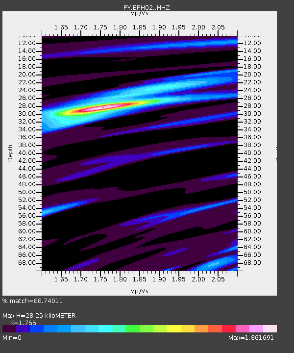
| Estimated Moho Depth: |
28.25 km |
| Estimated Crust Vp/Vs: |
1.75 |
| Assumed Crust Vp: |
6.264 km/s |
| Estimated Crust Vs: |
3.569 km/s |
| Estimated Crust Poisson's Ratio: |
0.26 |
|
| Radial Match: |
88.74011 % |
| Radial Bump: |
251 |
| Transverse Match: |
77.050964 % |
| Transverse Bump: |
355 |
| SOD ConfigId: |
11737051 |
| Insert Time: |
2019-04-25 11:15:15.022 +0000 |
| GWidth: |
2.5 |
| Max Bumps: |
400 |
| Tol: |
0.001 |
|

Signal To Noise
| Channel | StoN | STA | LTA |
| PY:BPH02: :HHZ:20160905T23:03:04.775024Z | 3.1661494 | 3.0288092E-7 | 9.566224E-8 |
| PY:BPH02: :HHN:20160905T23:03:04.775024Z | 2.2164361 | 1.7977503E-7 | 8.110995E-8 |
| PY:BPH02: :HHE:20160905T23:03:04.775024Z | 0.96772903 | 8.6836074E-8 | 8.9731806E-8 |
| Arrivals |
| Ps | 3.6 SECOND |
| PpPs | 12 SECOND |
| PsPs/PpSs | 15 SECOND |


