You are here: Home > Network List > PY - PFO Array Stations List
> Station BPH02 Pinon Flat Observatory, CA, USA > Earthquake Result Viewer
BPH02 Pinon Flat Observatory, CA, USA - Earthquake Result Viewer
| Earthquake location: |
Tonga Islands Region |
| Earthquake latitude/longitude: |
-20.2/-173.0 |
| Earthquake time(UTC): |
2016/11/16 (321) 00:30:28 GMT |
| Earthquake Depth: |
10 km |
| Earthquake Magnitude: |
5.9 MB, 5.6 MWB |
| Earthquake Catalog/Contributor: |
NEIC PDE/NEIC COMCAT |
|
| Network: |
PY PFO Array |
| Station: |
BPH02 Pinon Flat Observatory, CA, USA |
| Lat/Lon: |
33.61 N/116.46 W |
| Elevation: |
1289 m |
|
| Distance: |
75.9 deg |
| Az: |
45.853 deg |
| Baz: |
233.863 deg |
| Ray Param: |
0.051350772 |
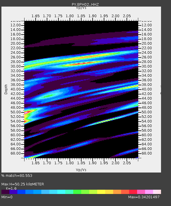
| Estimated Moho Depth: |
50.25 km |
| Estimated Crust Vp/Vs: |
1.60 |
| Assumed Crust Vp: |
6.264 km/s |
| Estimated Crust Vs: |
3.915 km/s |
| Estimated Crust Poisson's Ratio: |
0.18 |
|
| Radial Match: |
80.553 % |
| Radial Bump: |
335 |
| Transverse Match: |
62.077137 % |
| Transverse Bump: |
364 |
| SOD ConfigId: |
11737051 |
| Insert Time: |
2019-04-26 02:19:35.608 +0000 |
| GWidth: |
2.5 |
| Max Bumps: |
400 |
| Tol: |
0.001 |
|

Signal To Noise
| Channel | StoN | STA | LTA |
| PY:BPH02: :HHZ:20161116T00:41:44.07502Z | 3.1469572 | 5.8426224E-7 | 1.8565942E-7 |
| PY:BPH02: :HHN:20161116T00:41:44.07502Z | 1.9823413 | 1.6859967E-7 | 8.505078E-8 |
| PY:BPH02: :HHE:20161116T00:41:44.07502Z | 1.6245161 | 2.9621143E-7 | 1.8233825E-7 |
| Arrivals |
| Ps | 5.0 SECOND |
| PpPs | 20 SECOND |
| PsPs/PpSs | 25 SECOND |


