You are here: Home > Network List > PY - PFO Array Stations List
> Station BPH02 Pinon Flat Observatory, CA, USA > Earthquake Result Viewer
BPH02 Pinon Flat Observatory, CA, USA - Earthquake Result Viewer
| Earthquake location: |
Near East Coast Of Honshu, Japan |
| Earthquake latitude/longitude: |
37.4/141.4 |
| Earthquake time(UTC): |
2016/11/21 (326) 20:59:49 GMT |
| Earthquake Depth: |
11 km |
| Earthquake Magnitude: |
6.9 MWB, 7.3 MI |
| Earthquake Catalog/Contributor: |
NEIC PDE/NEIC COMCAT |
|
| Network: |
PY PFO Array |
| Station: |
BPH02 Pinon Flat Observatory, CA, USA |
| Lat/Lon: |
33.61 N/116.46 W |
| Elevation: |
1289 m |
|
| Distance: |
78.9 deg |
| Az: |
56.258 deg |
| Baz: |
307.475 deg |
| Ray Param: |
0.04935861 |
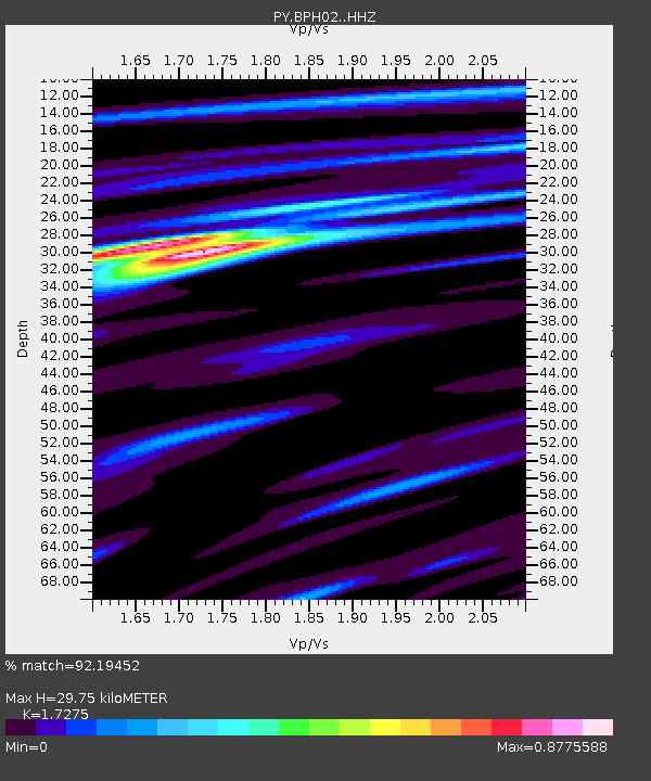
| Estimated Moho Depth: |
29.75 km |
| Estimated Crust Vp/Vs: |
1.73 |
| Assumed Crust Vp: |
6.264 km/s |
| Estimated Crust Vs: |
3.626 km/s |
| Estimated Crust Poisson's Ratio: |
0.25 |
|
| Radial Match: |
92.19452 % |
| Radial Bump: |
254 |
| Transverse Match: |
68.70283 % |
| Transverse Bump: |
386 |
| SOD ConfigId: |
11737051 |
| Insert Time: |
2019-04-26 03:10:56.604 +0000 |
| GWidth: |
2.5 |
| Max Bumps: |
400 |
| Tol: |
0.001 |
|

Signal To Noise
| Channel | StoN | STA | LTA |
| PY:BPH02: :HHZ:20161121T21:11:20.564993Z | 3.5535638 | 1.1653817E-6 | 3.279473E-7 |
| PY:BPH02: :HHN:20161121T21:11:20.564993Z | 0.9293251 | 4.0402404E-7 | 4.3474992E-7 |
| PY:BPH02: :HHE:20161121T21:11:20.564993Z | 2.681511 | 4.809031E-7 | 1.7934035E-7 |
| Arrivals |
| Ps | 3.6 SECOND |
| PpPs | 13 SECOND |
| PsPs/PpSs | 16 SECOND |


