You are here: Home > Network List > PY - PFO Array Stations List
> Station BPH02 Pinon Flat Observatory, CA, USA > Earthquake Result Viewer
BPH02 Pinon Flat Observatory, CA, USA - Earthquake Result Viewer
| Earthquake location: |
Solomon Islands |
| Earthquake latitude/longitude: |
-11.0/161.3 |
| Earthquake time(UTC): |
2016/12/09 (344) 19:43:23 GMT |
| Earthquake Depth: |
18 km |
| Earthquake Magnitude: |
5.5 mb |
| Earthquake Catalog/Contributor: |
NEIC PDE/us |
|
| Network: |
PY PFO Array |
| Station: |
BPH02 Pinon Flat Observatory, CA, USA |
| Lat/Lon: |
33.61 N/116.46 W |
| Elevation: |
1289 m |
|
| Distance: |
89.6 deg |
| Az: |
55.777 deg |
| Baz: |
256.643 deg |
| Ray Param: |
0.04173144 |
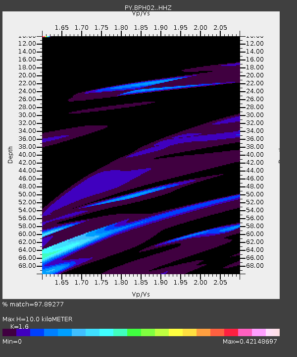
| Estimated Moho Depth: |
10.0 km |
| Estimated Crust Vp/Vs: |
1.60 |
| Assumed Crust Vp: |
6.264 km/s |
| Estimated Crust Vs: |
3.915 km/s |
| Estimated Crust Poisson's Ratio: |
0.18 |
|
| Radial Match: |
97.89277 % |
| Radial Bump: |
400 |
| Transverse Match: |
55.697803 % |
| Transverse Bump: |
400 |
| SOD ConfigId: |
11737051 |
| Insert Time: |
2019-04-26 06:51:11.088 +0000 |
| GWidth: |
2.5 |
| Max Bumps: |
400 |
| Tol: |
0.001 |
|

Signal To Noise
| Channel | StoN | STA | LTA |
| PY:BPH02: :HHZ:20161209T19:55:48.880002Z | 1.938925 | 1.0148736E-5 | 5.2342075E-6 |
| PY:BPH02: :HHN:20161209T19:55:48.880002Z | 2.2009456 | 2.8062664E-6 | 1.2750276E-6 |
| PY:BPH02: :HHE:20161209T19:55:48.880002Z | 0.976301 | 2.278791E-6 | 2.334107E-6 |
| Arrivals |
| Ps | 1.0 SECOND |
| PpPs | 4.1 SECOND |
| PsPs/PpSs | 5.0 SECOND |


