You are here: Home > Network List > PY - PFO Array Stations List
> Station BPH02 Pinon Flat Observatory, CA, USA > Earthquake Result Viewer
BPH02 Pinon Flat Observatory, CA, USA - Earthquake Result Viewer
| Earthquake location: |
Mariana Islands Region |
| Earthquake latitude/longitude: |
21.5/145.4 |
| Earthquake time(UTC): |
2016/12/21 (356) 16:43:58 GMT |
| Earthquake Depth: |
17 km |
| Earthquake Magnitude: |
5.9 Mwb |
| Earthquake Catalog/Contributor: |
NEIC PDE/us |
|
| Network: |
PY PFO Array |
| Station: |
BPH02 Pinon Flat Observatory, CA, USA |
| Lat/Lon: |
33.61 N/116.46 W |
| Elevation: |
1289 m |
|
| Distance: |
84.8 deg |
| Az: |
56.046 deg |
| Baz: |
292.263 deg |
| Ray Param: |
0.045212455 |
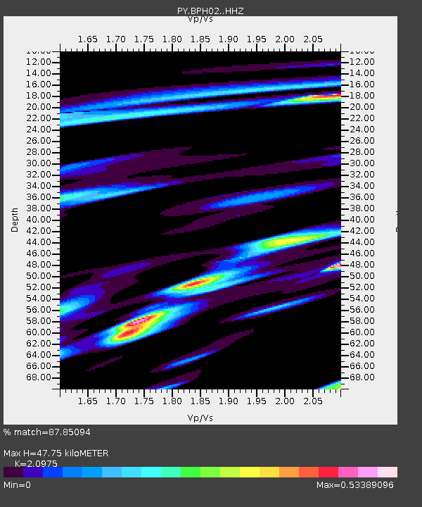
| Estimated Moho Depth: |
47.75 km |
| Estimated Crust Vp/Vs: |
2.10 |
| Assumed Crust Vp: |
6.264 km/s |
| Estimated Crust Vs: |
2.986 km/s |
| Estimated Crust Poisson's Ratio: |
0.35 |
|
| Radial Match: |
87.85094 % |
| Radial Bump: |
384 |
| Transverse Match: |
77.44645 % |
| Transverse Bump: |
324 |
| SOD ConfigId: |
11737051 |
| Insert Time: |
2019-04-26 10:18:19.712 +0000 |
| GWidth: |
2.5 |
| Max Bumps: |
400 |
| Tol: |
0.001 |
|

Signal To Noise
| Channel | StoN | STA | LTA |
| PY:BPH02: :HHZ:20161221T16:55:59.864973Z | 3.911882 | 9.670417E-7 | 2.4720626E-7 |
| PY:BPH02: :HHN:20161221T16:55:59.864973Z | 1.493643 | 1.383481E-7 | 9.26246E-8 |
| PY:BPH02: :HHE:20161221T16:55:59.864973Z | 1.1232033 | 3.5791982E-7 | 3.186599E-7 |
| Arrivals |
| Ps | 8.5 SECOND |
| PpPs | 23 SECOND |
| PsPs/PpSs | 32 SECOND |


