You are here: Home > Network List > PY - PFO Array Stations List
> Station BPH02 Pinon Flat Observatory, CA, USA > Earthquake Result Viewer
BPH02 Pinon Flat Observatory, CA, USA - Earthquake Result Viewer
| Earthquake location: |
Off East Coast Of Honshu, Japan |
| Earthquake latitude/longitude: |
38.0/144.7 |
| Earthquake time(UTC): |
2017/09/20 (263) 16:37:16 GMT |
| Earthquake Depth: |
10 km |
| Earthquake Magnitude: |
6.1 Mww |
| Earthquake Catalog/Contributor: |
NEIC PDE/us |
|
| Network: |
PY PFO Array |
| Station: |
BPH02 Pinon Flat Observatory, CA, USA |
| Lat/Lon: |
33.61 N/116.46 W |
| Elevation: |
1289 m |
|
| Distance: |
76.4 deg |
| Az: |
58.047 deg |
| Baz: |
306.542 deg |
| Ray Param: |
0.051050074 |
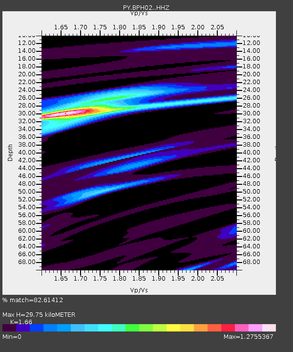
| Estimated Moho Depth: |
29.75 km |
| Estimated Crust Vp/Vs: |
1.66 |
| Assumed Crust Vp: |
6.264 km/s |
| Estimated Crust Vs: |
3.773 km/s |
| Estimated Crust Poisson's Ratio: |
0.22 |
|
| Radial Match: |
82.61412 % |
| Radial Bump: |
283 |
| Transverse Match: |
76.56955 % |
| Transverse Bump: |
291 |
| SOD ConfigId: |
13570011 |
| Insert Time: |
2019-04-28 20:16:05.495 +0000 |
| GWidth: |
2.5 |
| Max Bumps: |
400 |
| Tol: |
0.001 |
|

Signal To Noise
| Channel | StoN | STA | LTA |
| PY:BPH02: :HHZ:20170920T16:48:34.110005Z | 6.9040084 | 2.3290074E-6 | 3.3734133E-7 |
| PY:BPH02: :HHN:20170920T16:48:34.110005Z | 2.4910314 | 6.054387E-7 | 2.430474E-7 |
| PY:BPH02: :HHE:20170920T16:48:34.110005Z | 2.1081736 | 5.7664795E-7 | 2.7352962E-7 |
| Arrivals |
| Ps | 3.2 SECOND |
| PpPs | 12 SECOND |
| PsPs/PpSs | 15 SECOND |


