You are here: Home > Network List > PY - PFO Array Stations List
> Station BPH02 Pinon Flat Observatory, CA, USA > Earthquake Result Viewer
BPH02 Pinon Flat Observatory, CA, USA - Earthquake Result Viewer
| Earthquake location: |
Alaska Peninsula |
| Earthquake latitude/longitude: |
54.4/-160.8 |
| Earthquake time(UTC): |
2018/07/19 (200) 14:16:27 GMT |
| Earthquake Depth: |
22 km |
| Earthquake Magnitude: |
5.8 Mww |
| Earthquake Catalog/Contributor: |
NEIC PDE/us |
|
| Network: |
PY PFO Array |
| Station: |
BPH02 Pinon Flat Observatory, CA, USA |
| Lat/Lon: |
33.61 N/116.46 W |
| Elevation: |
1289 m |
|
| Distance: |
37.3 deg |
| Az: |
105.589 deg |
| Baz: |
317.617 deg |
| Ray Param: |
0.07619989 |
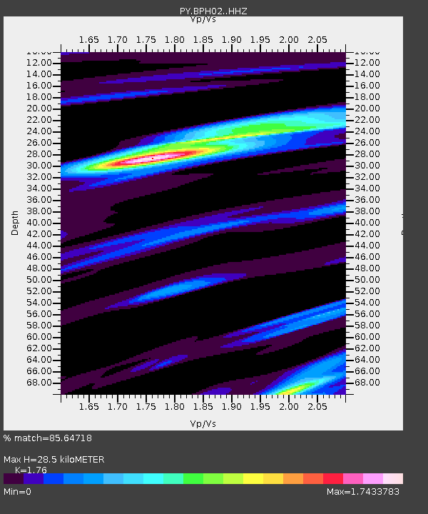
| Estimated Moho Depth: |
28.5 km |
| Estimated Crust Vp/Vs: |
1.76 |
| Assumed Crust Vp: |
6.264 km/s |
| Estimated Crust Vs: |
3.559 km/s |
| Estimated Crust Poisson's Ratio: |
0.26 |
|
| Radial Match: |
85.64718 % |
| Radial Bump: |
355 |
| Transverse Match: |
64.3042 % |
| Transverse Bump: |
400 |
| SOD ConfigId: |
13570011 |
| Insert Time: |
2019-04-30 14:39:04.845 +0000 |
| GWidth: |
2.5 |
| Max Bumps: |
400 |
| Tol: |
0.001 |
|

Signal To Noise
| Channel | StoN | STA | LTA |
| PY:BPH02: :HHZ:20180719T14:23:06.610007Z | 3.6409917 | 3.166434E-7 | 8.6966246E-8 |
| PY:BPH02: :HHN:20180719T14:23:06.610007Z | 3.1860933 | 1.560554E-7 | 4.8980176E-8 |
| PY:BPH02: :HHE:20180719T14:23:06.610007Z | 1.4090986 | 9.690579E-8 | 6.877147E-8 |
| Arrivals |
| Ps | 3.7 SECOND |
| PpPs | 12 SECOND |
| PsPs/PpSs | 15 SECOND |


