You are here: Home > Network List > PY - PFO Array Stations List
> Station BPH02 Pinon Flat Observatory, CA, USA > Earthquake Result Viewer
BPH02 Pinon Flat Observatory, CA, USA - Earthquake Result Viewer
| Earthquake location: |
Fox Islands, Aleutian Islands |
| Earthquake latitude/longitude: |
51.7/-171.2 |
| Earthquake time(UTC): |
2020/08/16 (229) 20:05:57 GMT |
| Earthquake Depth: |
43 km |
| Earthquake Magnitude: |
5.7 Mi |
| Earthquake Catalog/Contributor: |
NEIC PDE/at |
|
| Network: |
PY PFO Array |
| Station: |
BPH02 Pinon Flat Observatory, CA, USA |
| Lat/Lon: |
33.61 N/116.46 W |
| Elevation: |
1289 m |
|
| Distance: |
43.0 deg |
| Az: |
92.864 deg |
| Baz: |
311.842 deg |
| Ray Param: |
0.07271528 |
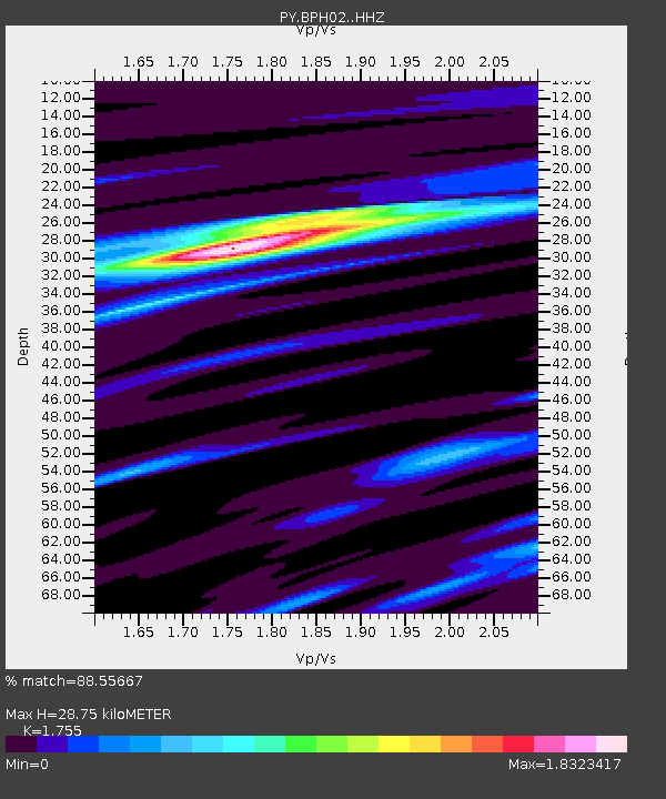
| Estimated Moho Depth: |
28.75 km |
| Estimated Crust Vp/Vs: |
1.75 |
| Assumed Crust Vp: |
6.264 km/s |
| Estimated Crust Vs: |
3.569 km/s |
| Estimated Crust Poisson's Ratio: |
0.26 |
|
| Radial Match: |
88.55667 % |
| Radial Bump: |
279 |
| Transverse Match: |
71.42142 % |
| Transverse Bump: |
397 |
| SOD ConfigId: |
21709731 |
| Insert Time: |
2020-08-30 20:25:17.662 +0000 |
| GWidth: |
2.5 |
| Max Bumps: |
400 |
| Tol: |
0.001 |
|

Signal To Noise
| Channel | StoN | STA | LTA |
| PY:BPH02: :HHZ:20200816T20:13:21.860992Z | 4.9591384 | 3.4468488E-7 | 6.950499E-8 |
| PY:BPH02: :HHN:20200816T20:13:21.860992Z | 1.5978174 | 1.5342756E-7 | 9.6023214E-8 |
| PY:BPH02: :HHE:20200816T20:13:21.860992Z | 2.363779 | 1.5065726E-7 | 6.373576E-8 |
| Arrivals |
| Ps | 3.7 SECOND |
| PpPs | 12 SECOND |
| PsPs/PpSs | 16 SECOND |


