You are here: Home > Network List > PY - PFO Array Stations List
> Station BPH02 Pinon Flat Observatory, CA, USA > Earthquake Result Viewer
BPH02 Pinon Flat Observatory, CA, USA - Earthquake Result Viewer
| Earthquake location: |
Tonga Islands |
| Earthquake latitude/longitude: |
-15.3/-173.3 |
| Earthquake time(UTC): |
2020/10/25 (299) 11:47:37 GMT |
| Earthquake Depth: |
44 km |
| Earthquake Magnitude: |
6.1 Mi |
| Earthquake Catalog/Contributor: |
NEIC PDE/pt |
|
| Network: |
PY PFO Array |
| Station: |
BPH02 Pinon Flat Observatory, CA, USA |
| Lat/Lon: |
33.61 N/116.46 W |
| Elevation: |
1289 m |
|
| Distance: |
72.8 deg |
| Az: |
47.025 deg |
| Baz: |
237.777 deg |
| Ray Param: |
0.0533338 |
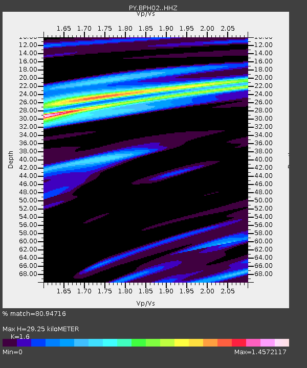
| Estimated Moho Depth: |
29.25 km |
| Estimated Crust Vp/Vs: |
1.60 |
| Assumed Crust Vp: |
6.264 km/s |
| Estimated Crust Vs: |
3.915 km/s |
| Estimated Crust Poisson's Ratio: |
0.18 |
|
| Radial Match: |
80.94716 % |
| Radial Bump: |
400 |
| Transverse Match: |
45.723984 % |
| Transverse Bump: |
374 |
| SOD ConfigId: |
22732711 |
| Insert Time: |
2020-11-08 12:02:05.190 +0000 |
| GWidth: |
2.5 |
| Max Bumps: |
400 |
| Tol: |
0.001 |
|

Signal To Noise
| Channel | StoN | STA | LTA |
| PY:BPH02: :HHZ:20201025T11:58:30.145996Z | 1.1829128 | 3.189536E-7 | 2.6963406E-7 |
| PY:BPH02: :HHN:20201025T11:58:30.145996Z | 2.299747 | 2.3985484E-7 | 1.04296184E-7 |
| PY:BPH02: :HHE:20201025T11:58:30.145996Z | 2.617297 | 4.82461E-7 | 1.843356E-7 |
| Arrivals |
| Ps | 2.9 SECOND |
| PpPs | 12 SECOND |
| PsPs/PpSs | 15 SECOND |


