You are here: Home > Network List > PY - PFO Array Stations List
> Station BPH02 Pinon Flat Observatory, CA, USA > Earthquake Result Viewer
BPH02 Pinon Flat Observatory, CA, USA - Earthquake Result Viewer
| Earthquake location: |
Near East Coast Of Honshu, Japan |
| Earthquake latitude/longitude: |
38.1/141.8 |
| Earthquake time(UTC): |
2021/05/01 (121) 01:27:30 GMT |
| Earthquake Depth: |
56 km |
| Earthquake Magnitude: |
6.6 Mi |
| Earthquake Catalog/Contributor: |
NEIC PDE/at |
|
| Network: |
PY PFO Array |
| Station: |
BPH02 Pinon Flat Observatory, CA, USA |
| Lat/Lon: |
33.61 N/116.46 W |
| Elevation: |
1289 m |
|
| Distance: |
78.2 deg |
| Az: |
56.585 deg |
| Baz: |
307.898 deg |
| Ray Param: |
0.04970385 |
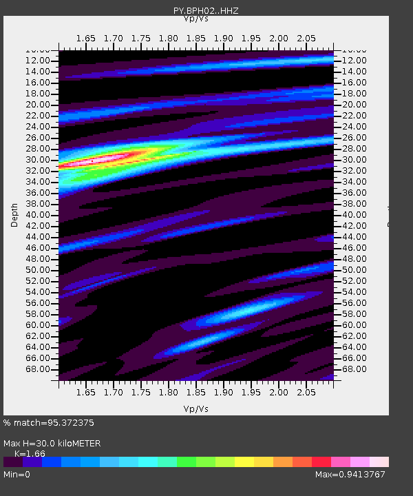
| Estimated Moho Depth: |
30.0 km |
| Estimated Crust Vp/Vs: |
1.66 |
| Assumed Crust Vp: |
6.264 km/s |
| Estimated Crust Vs: |
3.773 km/s |
| Estimated Crust Poisson's Ratio: |
0.22 |
|
| Radial Match: |
95.372375 % |
| Radial Bump: |
220 |
| Transverse Match: |
81.2451 % |
| Transverse Bump: |
322 |
| SOD ConfigId: |
24334971 |
| Insert Time: |
2021-05-15 01:58:18.303 +0000 |
| GWidth: |
2.5 |
| Max Bumps: |
400 |
| Tol: |
0.001 |
|

Signal To Noise
| Channel | StoN | STA | LTA |
| PY:BPH02: :HHZ:20210501T01:38:52.491028Z | 6.509345 | 9.204762E-7 | 1.4140842E-7 |
| PY:BPH02: :HHN:20210501T01:38:52.491028Z | 2.655528 | 3.1780985E-7 | 1.1967859E-7 |
| PY:BPH02: :HHE:20210501T01:38:52.491028Z | 3.5459876 | 2.689482E-7 | 7.584579E-8 |
| Arrivals |
| Ps | 3.3 SECOND |
| PpPs | 12 SECOND |
| PsPs/PpSs | 16 SECOND |


