You are here: Home > Network List > PY - PFO Array Stations List
> Station BPH02 Pinon Flat Observatory, CA, USA > Earthquake Result Viewer
BPH02 Pinon Flat Observatory, CA, USA - Earthquake Result Viewer
| Earthquake location: |
Kermadec Islands, New Zealand |
| Earthquake latitude/longitude: |
-30.2/-177.8 |
| Earthquake time(UTC): |
2021/06/20 (171) 17:05:48 GMT |
| Earthquake Depth: |
10 km |
| Earthquake Magnitude: |
6.5 mww |
| Earthquake Catalog/Contributor: |
NEIC PDE/us |
|
| Network: |
PY PFO Array |
| Station: |
BPH02 Pinon Flat Observatory, CA, USA |
| Lat/Lon: |
33.61 N/116.46 W |
| Elevation: |
1289 m |
|
| Distance: |
86.0 deg |
| Az: |
47.242 deg |
| Baz: |
229.605 deg |
| Ray Param: |
0.0443962 |
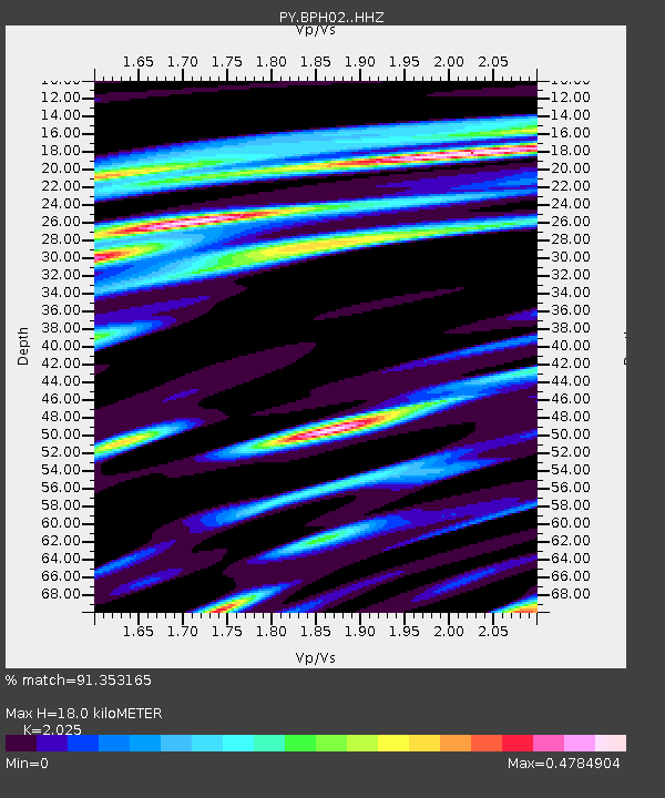
| Estimated Moho Depth: |
18.0 km |
| Estimated Crust Vp/Vs: |
2.03 |
| Assumed Crust Vp: |
6.264 km/s |
| Estimated Crust Vs: |
3.093 km/s |
| Estimated Crust Poisson's Ratio: |
0.34 |
|
| Radial Match: |
91.353165 % |
| Radial Bump: |
388 |
| Transverse Match: |
78.9656 % |
| Transverse Bump: |
400 |
| SOD ConfigId: |
25131211 |
| Insert Time: |
2021-07-04 17:26:16.804 +0000 |
| GWidth: |
2.5 |
| Max Bumps: |
400 |
| Tol: |
0.001 |
|

Signal To Noise
| Channel | StoN | STA | LTA |
| PY:BPH02: :HHZ:20210620T17:17:56.89101Z | 15.523756 | 2.0784632E-6 | 1.338892E-7 |
| PY:BPH02: :HHN:20210620T17:17:56.89101Z | 2.7537923 | 4.1944247E-7 | 1.5231448E-7 |
| PY:BPH02: :HHE:20210620T17:17:56.89101Z | 2.783004 | 3.9754383E-7 | 1.4284701E-7 |
| Arrivals |
| Ps | 3.0 SECOND |
| PpPs | 8.5 SECOND |
| PsPs/PpSs | 12 SECOND |


