You are here: Home > Network List > PY - PFO Array Stations List
> Station BPH02 Pinon Flat Observatory, CA, USA > Earthquake Result Viewer
BPH02 Pinon Flat Observatory, CA, USA - Earthquake Result Viewer
| Earthquake location: |
Southeast Of Loyalty Islands |
| Earthquake latitude/longitude: |
-22.7/170.3 |
| Earthquake time(UTC): |
2022/03/31 (090) 05:44:01 GMT |
| Earthquake Depth: |
10 km |
| Earthquake Magnitude: |
7.2 Mi |
| Earthquake Catalog/Contributor: |
NEIC PDE/at |
|
| Network: |
PY PFO Array |
| Station: |
BPH02 Pinon Flat Observatory, CA, USA |
| Lat/Lon: |
33.61 N/116.46 W |
| Elevation: |
1289 m |
|
| Distance: |
89.4 deg |
| Az: |
53.048 deg |
| Baz: |
242.166 deg |
| Ray Param: |
0.041893408 |
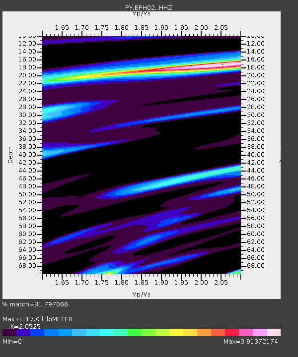
| Estimated Moho Depth: |
17.0 km |
| Estimated Crust Vp/Vs: |
2.05 |
| Assumed Crust Vp: |
6.264 km/s |
| Estimated Crust Vs: |
3.052 km/s |
| Estimated Crust Poisson's Ratio: |
0.34 |
|
| Radial Match: |
81.797066 % |
| Radial Bump: |
328 |
| Transverse Match: |
71.89919 % |
| Transverse Bump: |
400 |
| SOD ConfigId: |
27527651 |
| Insert Time: |
2022-04-14 06:05:12.187 +0000 |
| GWidth: |
2.5 |
| Max Bumps: |
400 |
| Tol: |
0.001 |
|

Signal To Noise
| Channel | StoN | STA | LTA |
| PY:BPH02: :HHZ:20220331T05:56:26.161011Z | 6.2029514 | 1.3505564E-6 | 2.1772804E-7 |
| PY:BPH02: :HHN:20220331T05:56:26.161011Z | 1.1825588 | 2.0450376E-7 | 1.7293328E-7 |
| PY:BPH02: :HHE:20220331T05:56:26.161011Z | 2.5522392 | 4.8453995E-7 | 1.8984895E-7 |
| Arrivals |
| Ps | 2.9 SECOND |
| PpPs | 8.1 SECOND |
| PsPs/PpSs | 11 SECOND |


