You are here: Home > Network List > PY - PFO Array Stations List
> Station BPH02 Pinon Flat Observatory, CA, USA > Earthquake Result Viewer
BPH02 Pinon Flat Observatory, CA, USA - Earthquake Result Viewer
| Earthquake location: |
Samoa Islands Region |
| Earthquake latitude/longitude: |
-15.7/-172.5 |
| Earthquake time(UTC): |
2022/12/04 (338) 19:24:27 GMT |
| Earthquake Depth: |
148 km |
| Earthquake Magnitude: |
6.9 Mi |
| Earthquake Catalog/Contributor: |
NEIC PDE/at |
|
| Network: |
PY PFO Array |
| Station: |
BPH02 Pinon Flat Observatory, CA, USA |
| Lat/Lon: |
33.61 N/116.46 W |
| Elevation: |
1289 m |
|
| Distance: |
72.5 deg |
| Az: |
46.538 deg |
| Baz: |
236.899 deg |
| Ray Param: |
0.053250737 |
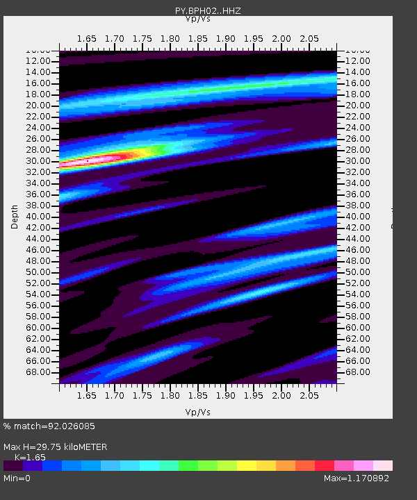
| Estimated Moho Depth: |
29.75 km |
| Estimated Crust Vp/Vs: |
1.65 |
| Assumed Crust Vp: |
6.264 km/s |
| Estimated Crust Vs: |
3.796 km/s |
| Estimated Crust Poisson's Ratio: |
0.21 |
|
| Radial Match: |
92.026085 % |
| Radial Bump: |
258 |
| Transverse Match: |
78.94371 % |
| Transverse Bump: |
400 |
| SOD ConfigId: |
29823551 |
| Insert Time: |
2022-12-18 20:15:01.556 +0000 |
| GWidth: |
2.5 |
| Max Bumps: |
400 |
| Tol: |
0.001 |
|

Signal To Noise
| Channel | StoN | STA | LTA |
| PY:BPH02: :HHZ:20221204T19:35:06.604004Z | 3.6557362 | 1.5897581E-6 | 4.3486673E-7 |
| PY:BPH02: :HHN:20221204T19:35:06.604004Z | 0.9401684 | 2.724491E-7 | 2.8978758E-7 |
| PY:BPH02: :HHE:20221204T19:35:06.604004Z | 1.882635 | 4.6589335E-7 | 2.4746876E-7 |
| Arrivals |
| Ps | 3.2 SECOND |
| PpPs | 12 SECOND |
| PsPs/PpSs | 15 SECOND |


