You are here: Home > Network List > PY - PFO Array Stations List
> Station BPH02 Pinon Flat Observatory, CA, USA > Earthquake Result Viewer
BPH02 Pinon Flat Observatory, CA, USA - Earthquake Result Viewer
| Earthquake location: |
Kuril Islands |
| Earthquake latitude/longitude: |
50.7/156.3 |
| Earthquake time(UTC): |
2023/09/01 (244) 20:49:54 GMT |
| Earthquake Depth: |
141 km |
| Earthquake Magnitude: |
6.1 Mww |
| Earthquake Catalog/Contributor: |
NEIC PDE/us |
|
| Network: |
PY PFO Array |
| Station: |
BPH02 Pinon Flat Observatory, CA, USA |
| Lat/Lon: |
33.61 N/116.46 W |
| Elevation: |
1289 m |
|
| Distance: |
63.2 deg |
| Az: |
69.045 deg |
| Baz: |
314.636 deg |
| Ray Param: |
0.05932762 |
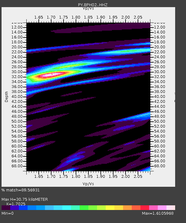
| Estimated Moho Depth: |
30.75 km |
| Estimated Crust Vp/Vs: |
1.70 |
| Assumed Crust Vp: |
6.264 km/s |
| Estimated Crust Vs: |
3.679 km/s |
| Estimated Crust Poisson's Ratio: |
0.24 |
|
| Radial Match: |
89.56931 % |
| Radial Bump: |
384 |
| Transverse Match: |
75.16567 % |
| Transverse Bump: |
400 |
| SOD ConfigId: |
31937991 |
| Insert Time: |
2023-09-15 21:20:36.784 +0000 |
| GWidth: |
2.5 |
| Max Bumps: |
400 |
| Tol: |
0.001 |
|

Signal To Noise
| Channel | StoN | STA | LTA |
| PY:BPH02: :HHZ:20230901T20:59:37.293995Z | 4.672326 | 1.0155024E-6 | 2.1734407E-7 |
| PY:BPH02: :HHN:20230901T20:59:37.293995Z | 2.8669345 | 4.2789034E-7 | 1.4925013E-7 |
| PY:BPH02: :HHE:20230901T20:59:37.293995Z | 2.3146865 | 4.1760669E-7 | 1.8041608E-7 |
| Arrivals |
| Ps | 3.6 SECOND |
| PpPs | 13 SECOND |
| PsPs/PpSs | 16 SECOND |


