You are here: Home > Network List > PY - PFO Array Stations List
> Station BPH02 Pinon Flat Observatory, CA, USA > Earthquake Result Viewer
BPH02 Pinon Flat Observatory, CA, USA - Earthquake Result Viewer
| Earthquake location: |
E. Caroline Islands, Micronesia |
| Earthquake latitude/longitude: |
0.8/146.1 |
| Earthquake time(UTC): |
2014/08/03 (215) 00:22:03 GMT |
| Earthquake Depth: |
11 km |
| Earthquake Magnitude: |
6.9 MWW, 6.8 MWB, 6.9 MWC, 7.2 MI |
| Earthquake Catalog/Contributor: |
NEIC PDE/NEIC COMCAT |
|
| Network: |
PY PFO Array |
| Station: |
BPH02 Pinon Flat Observatory, CA, USA |
| Lat/Lon: |
33.61 N/116.46 W |
| Elevation: |
1289 m |
|
| Distance: |
95.7 deg |
| Az: |
56.273 deg |
| Baz: |
274.794 deg |
| Ray Param: |
0.040710885 |
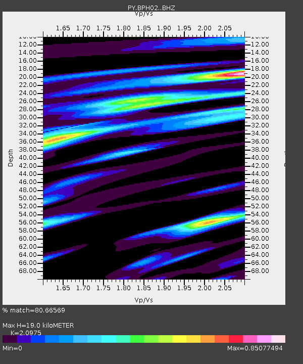
| Estimated Moho Depth: |
19.0 km |
| Estimated Crust Vp/Vs: |
2.10 |
| Assumed Crust Vp: |
6.264 km/s |
| Estimated Crust Vs: |
2.986 km/s |
| Estimated Crust Poisson's Ratio: |
0.35 |
|
| Radial Match: |
80.66569 % |
| Radial Bump: |
400 |
| Transverse Match: |
76.32012 % |
| Transverse Bump: |
400 |
| SOD ConfigId: |
3390531 |
| Insert Time: |
2019-04-13 04:04:33.386 +0000 |
| GWidth: |
2.5 |
| Max Bumps: |
400 |
| Tol: |
0.001 |
|

Signal To Noise
| Channel | StoN | STA | LTA |
| PY:BPH02: :BHZ:20140803T00:34:57.749978Z | 1.7833946 | 1.6600461E-7 | 9.30835E-8 |
| PY:BPH02: :BHN:20140803T00:34:57.749978Z | 1.6222409 | 8.868151E-8 | 5.4666057E-8 |
| PY:BPH02: :BHE:20140803T00:34:57.749978Z | 1.9473468 | 8.387768E-8 | 4.3072802E-8 |
| Arrivals |
| Ps | 3.4 SECOND |
| PpPs | 9.2 SECOND |
| PsPs/PpSs | 13 SECOND |


