You are here: Home > Network List > PY - PFO Array Stations List
> Station BPH02 Pinon Flat Observatory, CA, USA > Earthquake Result Viewer
BPH02 Pinon Flat Observatory, CA, USA - Earthquake Result Viewer
| Earthquake location: |
Volcano Islands, Japan Region |
| Earthquake latitude/longitude: |
24.4/142.6 |
| Earthquake time(UTC): |
2014/06/29 (180) 05:56:31 GMT |
| Earthquake Depth: |
43 km |
| Earthquake Magnitude: |
6.2 MWP |
| Earthquake Catalog/Contributor: |
NEIC PDE/NEIC COMCAT |
|
| Network: |
PY PFO Array |
| Station: |
BPH02 Pinon Flat Observatory, CA, USA |
| Lat/Lon: |
33.61 N/116.46 W |
| Elevation: |
1289 m |
|
| Distance: |
85.3 deg |
| Az: |
55.293 deg |
| Baz: |
296.09 deg |
| Ray Param: |
0.044788484 |
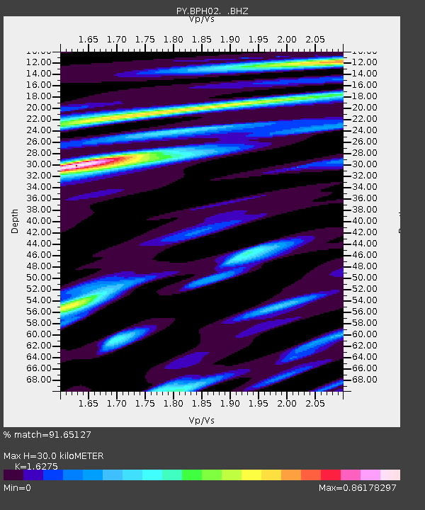
| Estimated Moho Depth: |
30.0 km |
| Estimated Crust Vp/Vs: |
1.63 |
| Assumed Crust Vp: |
6.264 km/s |
| Estimated Crust Vs: |
3.849 km/s |
| Estimated Crust Poisson's Ratio: |
0.20 |
|
| Radial Match: |
91.65127 % |
| Radial Bump: |
400 |
| Transverse Match: |
82.80521 % |
| Transverse Bump: |
376 |
| SOD ConfigId: |
751272 |
| Insert Time: |
2014-07-13 06:52:47.684 +0000 |
| GWidth: |
2.5 |
| Max Bumps: |
400 |
| Tol: |
0.001 |
|

Signal To Noise
| Channel | StoN | STA | LTA |
| PY:BPH02: :BHZ:20140629T06:08:32.724985Z | 11.220536 | 1.2512729E-6 | 1.1151632E-7 |
| PY:BPH02: :BHN:20140629T06:08:32.724985Z | 3.3220038 | 2.232821E-7 | 6.721308E-8 |
| PY:BPH02: :BHE:20140629T06:08:32.724985Z | 3.6258156 | 3.884374E-7 | 1.0713104E-7 |
| Arrivals |
| Ps | 3.1 SECOND |
| PpPs | 12 SECOND |
| PsPs/PpSs | 15 SECOND |


