You are here: Home > Network List > PY - PFO Array Stations List
> Station BPH02 Pinon Flat Observatory, CA, USA > Earthquake Result Viewer
BPH02 Pinon Flat Observatory, CA, USA - Earthquake Result Viewer
| Earthquake location: |
Southeastern Alaska |
| Earthquake latitude/longitude: |
60.4/-140.3 |
| Earthquake time(UTC): |
2014/07/17 (198) 11:49:32 GMT |
| Earthquake Depth: |
0.6 km |
| Earthquake Magnitude: |
5.8 MI |
| Earthquake Catalog/Contributor: |
NEIC PDE/NEIC ALERT |
|
| Network: |
PY PFO Array |
| Station: |
BPH02 Pinon Flat Observatory, CA, USA |
| Lat/Lon: |
33.61 N/116.46 W |
| Elevation: |
1289 m |
|
| Distance: |
31.0 deg |
| Az: |
138.974 deg |
| Baz: |
336.995 deg |
| Ray Param: |
0.07919877 |
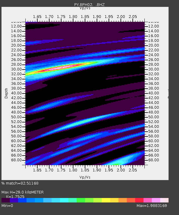
| Estimated Moho Depth: |
29.0 km |
| Estimated Crust Vp/Vs: |
1.75 |
| Assumed Crust Vp: |
6.264 km/s |
| Estimated Crust Vs: |
3.574 km/s |
| Estimated Crust Poisson's Ratio: |
0.26 |
|
| Radial Match: |
82.51168 % |
| Radial Bump: |
341 |
| Transverse Match: |
68.63254 % |
| Transverse Bump: |
400 |
| SOD ConfigId: |
751272 |
| Insert Time: |
2014-07-31 12:54:07.635 +0000 |
| GWidth: |
2.5 |
| Max Bumps: |
400 |
| Tol: |
0.001 |
|

Signal To Noise
| Channel | StoN | STA | LTA |
| PY:BPH02: :BHZ:20140717T11:55:20.200012Z | 3.4125378 | 4.1529364E-7 | 1.2169643E-7 |
| PY:BPH02: :BHN:20140717T11:55:20.200012Z | 5.8190765 | 3.3324244E-7 | 5.7267236E-8 |
| PY:BPH02: :BHE:20140717T11:55:20.200012Z | 1.1444649 | 1.2544493E-7 | 1.0961012E-7 |
| Arrivals |
| Ps | 3.8 SECOND |
| PpPs | 12 SECOND |
| PsPs/PpSs | 16 SECOND |


