You are here: Home > Network List > PY - PFO Array Stations List
> Station BPH02 Pinon Flat Observatory, CA, USA > Earthquake Result Viewer
BPH02 Pinon Flat Observatory, CA, USA - Earthquake Result Viewer
| Earthquake location: |
Fiji Islands Region |
| Earthquake latitude/longitude: |
-19.8/-178.4 |
| Earthquake time(UTC): |
2014/07/21 (202) 14:54:40 GMT |
| Earthquake Depth: |
616 km |
| Earthquake Magnitude: |
6.9 MWB, 6.9 MI |
| Earthquake Catalog/Contributor: |
NEIC PDE/NEIC ALERT |
|
| Network: |
PY PFO Array |
| Station: |
BPH02 Pinon Flat Observatory, CA, USA |
| Lat/Lon: |
33.61 N/116.46 W |
| Elevation: |
1289 m |
|
| Distance: |
79.4 deg |
| Az: |
48.548 deg |
| Baz: |
237.756 deg |
| Ray Param: |
0.047044907 |
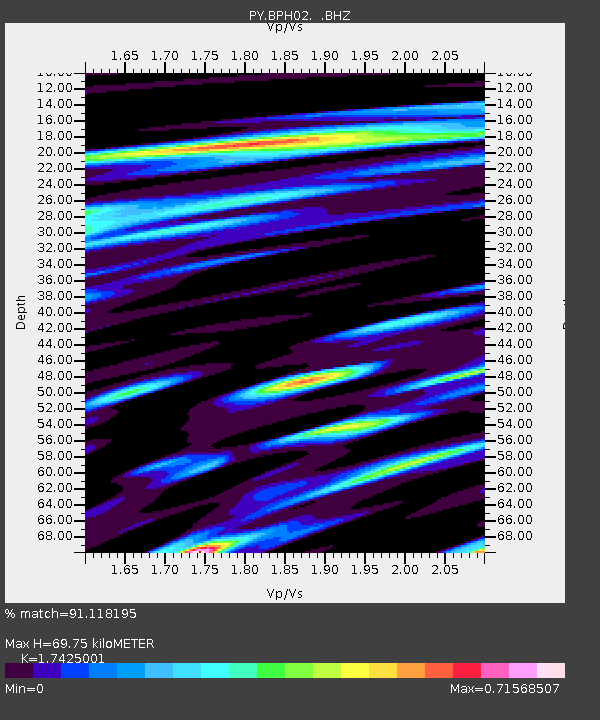
| Estimated Moho Depth: |
69.75 km |
| Estimated Crust Vp/Vs: |
1.74 |
| Assumed Crust Vp: |
6.264 km/s |
| Estimated Crust Vs: |
3.595 km/s |
| Estimated Crust Poisson's Ratio: |
0.25 |
|
| Radial Match: |
91.118195 % |
| Radial Bump: |
400 |
| Transverse Match: |
85.685684 % |
| Transverse Bump: |
400 |
| SOD ConfigId: |
751272 |
| Insert Time: |
2014-08-04 15:56:00.629 +0000 |
| GWidth: |
2.5 |
| Max Bumps: |
400 |
| Tol: |
0.001 |
|

Signal To Noise
| Channel | StoN | STA | LTA |
| PY:BPH02: :BHZ:20140721T15:05:13.449988Z | 33.62828 | 3.0671745E-6 | 9.1208186E-8 |
| PY:BPH02: :BHN:20140721T15:05:13.449988Z | 10.791213 | 5.9631725E-7 | 5.5259516E-8 |
| PY:BPH02: :BHE:20140721T15:05:13.449988Z | 14.123625 | 8.842137E-7 | 6.2605295E-8 |
| Arrivals |
| Ps | 8.5 SECOND |
| PpPs | 30 SECOND |
| PsPs/PpSs | 38 SECOND |


