You are here: Home > Network List > AE - Arizona Broadband Seismic Network Stations List
> Station 319A Douglas, AZ, USA > Earthquake Result Viewer
319A Douglas, AZ, USA - Earthquake Result Viewer
| Earthquake location: |
Near Coast Of Central Chile |
| Earthquake latitude/longitude: |
-31.5/-71.2 |
| Earthquake time(UTC): |
2015/09/22 (265) 07:12:59 GMT |
| Earthquake Depth: |
54 km |
| Earthquake Magnitude: |
6.1 MWB |
| Earthquake Catalog/Contributor: |
NEIC PDE/NEIC COMCAT |
|
| Network: |
AE Arizona Broadband Seismic Network |
| Station: |
319A Douglas, AZ, USA |
| Lat/Lon: |
31.38 N/109.28 W |
| Elevation: |
1187 m |
|
| Distance: |
72.2 deg |
| Az: |
326.347 deg |
| Baz: |
146.388 deg |
| Ray Param: |
0.053719938 |
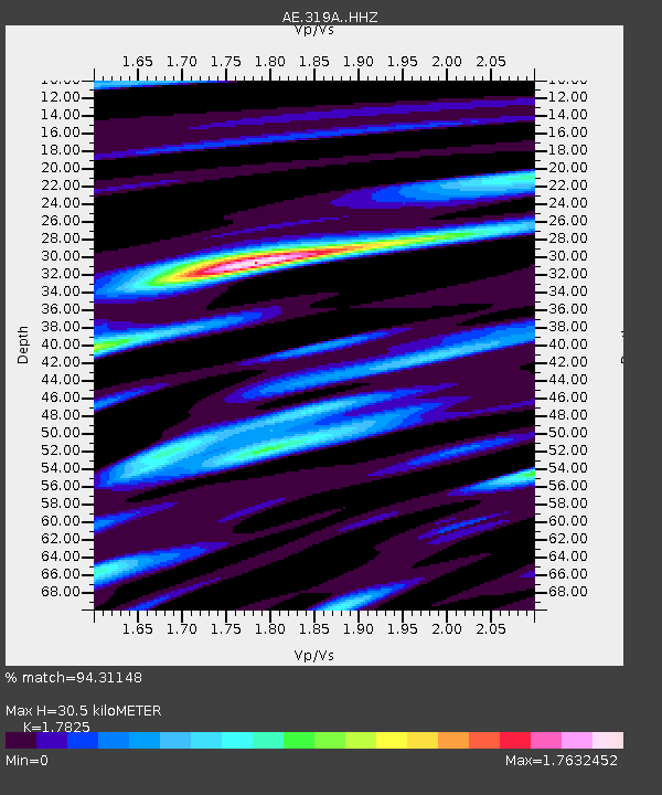
| Estimated Moho Depth: |
30.5 km |
| Estimated Crust Vp/Vs: |
1.78 |
| Assumed Crust Vp: |
6.182 km/s |
| Estimated Crust Vs: |
3.468 km/s |
| Estimated Crust Poisson's Ratio: |
0.27 |
|
| Radial Match: |
94.31148 % |
| Radial Bump: |
400 |
| Transverse Match: |
82.644196 % |
| Transverse Bump: |
400 |
| SOD ConfigId: |
7422571 |
| Insert Time: |
2019-04-20 23:55:22.376 +0000 |
| GWidth: |
2.5 |
| Max Bumps: |
400 |
| Tol: |
0.001 |
|

Signal To Noise
| Channel | StoN | STA | LTA |
| AE:319A: :HHZ:20150922T07:23:47.430029Z | 15.315503 | 1.0155975E-6 | 6.6311735E-8 |
| AE:319A: :HHN:20150922T07:23:47.430029Z | 4.7835236 | 3.8050123E-7 | 7.954414E-8 |
| AE:319A: :HHE:20150922T07:23:47.430029Z | 2.531366 | 2.1457105E-7 | 8.476492E-8 |
| Arrivals |
| Ps | 4.0 SECOND |
| PpPs | 13 SECOND |
| PsPs/PpSs | 17 SECOND |


