You are here: Home > Network List > AE - Arizona Broadband Seismic Network Stations List
> Station 319A Douglas, AZ, USA > Earthquake Result Viewer
319A Douglas, AZ, USA - Earthquake Result Viewer
| Earthquake location: |
Komandorskiye Ostrova Region |
| Earthquake latitude/longitude: |
56.2/164.1 |
| Earthquake time(UTC): |
2019/06/26 (177) 02:18:07 GMT |
| Earthquake Depth: |
10 km |
| Earthquake Magnitude: |
6.4 Mww |
| Earthquake Catalog/Contributor: |
NEIC PDE/us |
|
| Network: |
AE Arizona Broadband Seismic Network |
| Station: |
319A Douglas, AZ, USA |
| Lat/Lon: |
31.38 N/109.28 W |
| Elevation: |
1187 m |
|
| Distance: |
62.7 deg |
| Az: |
73.843 deg |
| Baz: |
321.119 deg |
| Ray Param: |
0.060031116 |
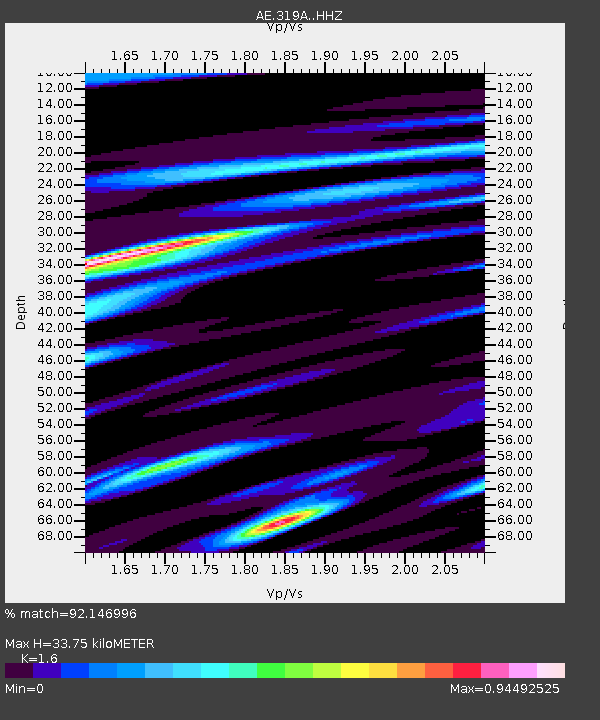
| Estimated Moho Depth: |
33.75 km |
| Estimated Crust Vp/Vs: |
1.60 |
| Assumed Crust Vp: |
6.182 km/s |
| Estimated Crust Vs: |
3.864 km/s |
| Estimated Crust Poisson's Ratio: |
0.18 |
|
| Radial Match: |
92.146996 % |
| Radial Bump: |
380 |
| Transverse Match: |
83.781075 % |
| Transverse Bump: |
400 |
| SOD ConfigId: |
18369291 |
| Insert Time: |
2019-07-10 02:18:53.252 +0000 |
| GWidth: |
2.5 |
| Max Bumps: |
400 |
| Tol: |
0.001 |
|

Signal To Noise
| Channel | StoN | STA | LTA |
| AE:319A: :HHZ:20190626T02:28:01.970001Z | 10.699388 | 9.171018E-7 | 8.571535E-8 |
| AE:319A: :HHN:20190626T02:28:01.970001Z | 2.1926281 | 2.787209E-7 | 1.2711726E-7 |
| AE:319A: :HHE:20190626T02:28:01.970001Z | 3.1860702 | 2.841959E-7 | 8.91995E-8 |
| Arrivals |
| Ps | 3.4 SECOND |
| PpPs | 14 SECOND |
| PsPs/PpSs | 17 SECOND |


