You are here: Home > Network List > AE - Arizona Broadband Seismic Network Stations List
> Station 319A Douglas, AZ, USA > Earthquake Result Viewer
319A Douglas, AZ, USA - Earthquake Result Viewer
| Earthquake location: |
Fiji Islands Region |
| Earthquake latitude/longitude: |
-18.0/-178.5 |
| Earthquake time(UTC): |
2020/10/06 (280) 10:11:46 GMT |
| Earthquake Depth: |
629 km |
| Earthquake Magnitude: |
6.0 Mww |
| Earthquake Catalog/Contributor: |
NEIC PDE/us |
|
| Network: |
AE Arizona Broadband Seismic Network |
| Station: |
319A Douglas, AZ, USA |
| Lat/Lon: |
31.38 N/109.28 W |
| Elevation: |
1187 m |
|
| Distance: |
82.6 deg |
| Az: |
53.748 deg |
| Baz: |
243.783 deg |
| Ray Param: |
0.044886257 |
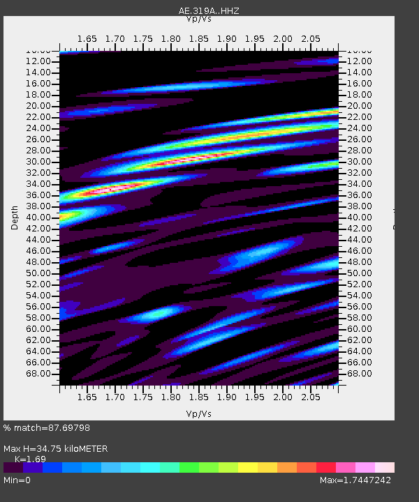
| Estimated Moho Depth: |
34.75 km |
| Estimated Crust Vp/Vs: |
1.69 |
| Assumed Crust Vp: |
6.182 km/s |
| Estimated Crust Vs: |
3.658 km/s |
| Estimated Crust Poisson's Ratio: |
0.23 |
|
| Radial Match: |
87.69798 % |
| Radial Bump: |
400 |
| Transverse Match: |
86.631004 % |
| Transverse Bump: |
400 |
| SOD ConfigId: |
22732711 |
| Insert Time: |
2020-10-20 10:12:57.652 +0000 |
| GWidth: |
2.5 |
| Max Bumps: |
400 |
| Tol: |
0.001 |
|

Signal To Noise
| Channel | StoN | STA | LTA |
| AE:319A: :HHZ:20201006T10:22:33.848974Z | 23.70126 | 3.7482087E-6 | 1.5814386E-7 |
| AE:319A: :HHN:20201006T10:22:33.848974Z | 8.4391575 | 6.679193E-7 | 7.9145266E-8 |
| AE:319A: :HHE:20201006T10:22:33.848974Z | 6.5317183 | 1.2034417E-6 | 1.842458E-7 |
| Arrivals |
| Ps | 4.0 SECOND |
| PpPs | 15 SECOND |
| PsPs/PpSs | 19 SECOND |


