You are here: Home > Network List > AE - Arizona Broadband Seismic Network Stations List
> Station 319A Douglas, AZ, USA > Earthquake Result Viewer
319A Douglas, AZ, USA - Earthquake Result Viewer
| Earthquake location: |
Alaska Peninsula |
| Earthquake latitude/longitude: |
55.3/-157.8 |
| Earthquake time(UTC): |
2021/07/29 (210) 06:15:45 GMT |
| Earthquake Depth: |
5.2 km |
| Earthquake Magnitude: |
7.3 ml |
| Earthquake Catalog/Contributor: |
NEIC PDE/ak |
|
| Network: |
AE Arizona Broadband Seismic Network |
| Station: |
319A Douglas, AZ, USA |
| Lat/Lon: |
31.38 N/109.28 W |
| Elevation: |
1187 m |
|
| Distance: |
41.5 deg |
| Az: |
104.709 deg |
| Baz: |
319.717 deg |
| Ray Param: |
0.0737587 |
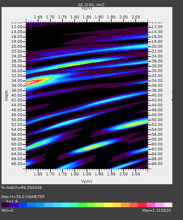
| Estimated Moho Depth: |
35.0 km |
| Estimated Crust Vp/Vs: |
1.60 |
| Assumed Crust Vp: |
6.182 km/s |
| Estimated Crust Vs: |
3.864 km/s |
| Estimated Crust Poisson's Ratio: |
0.18 |
|
| Radial Match: |
96.050446 % |
| Radial Bump: |
391 |
| Transverse Match: |
84.27697 % |
| Transverse Bump: |
400 |
| SOD ConfigId: |
25131211 |
| Insert Time: |
2021-08-12 06:16:08.962 +0000 |
| GWidth: |
2.5 |
| Max Bumps: |
400 |
| Tol: |
0.001 |
|

Signal To Noise
| Channel | StoN | STA | LTA |
| AE:319A: :HHZ:20210729T06:23:02.690005Z | 6.9057684 | 2.461176E-6 | 3.5639425E-7 |
| AE:319A: :HHN:20210729T06:23:02.690005Z | 7.265354 | 1.373388E-6 | 1.8903249E-7 |
| AE:319A: :HHE:20210729T06:23:02.690005Z | 7.6073 | 1.1525002E-6 | 1.5149924E-7 |
| Arrivals |
| Ps | 3.6 SECOND |
| PpPs | 14 SECOND |
| PsPs/PpSs | 17 SECOND |


