You are here: Home > Network List > AE - Arizona Broadband Seismic Network Stations List
> Station 319A Douglas, AZ, USA > Earthquake Result Viewer
319A Douglas, AZ, USA - Earthquake Result Viewer
| Earthquake location: |
North Of Svalbard |
| Earthquake latitude/longitude: |
84.3/0.8 |
| Earthquake time(UTC): |
2022/05/21 (141) 07:01:23 GMT |
| Earthquake Depth: |
10 km |
| Earthquake Magnitude: |
5.8 mww |
| Earthquake Catalog/Contributor: |
NEIC PDE/us |
|
| Network: |
AE Arizona Broadband Seismic Network |
| Station: |
319A Douglas, AZ, USA |
| Lat/Lon: |
31.38 N/109.28 W |
| Elevation: |
1187 m |
|
| Distance: |
60.9 deg |
| Az: |
293.196 deg |
| Baz: |
6.122 deg |
| Ray Param: |
0.061239384 |
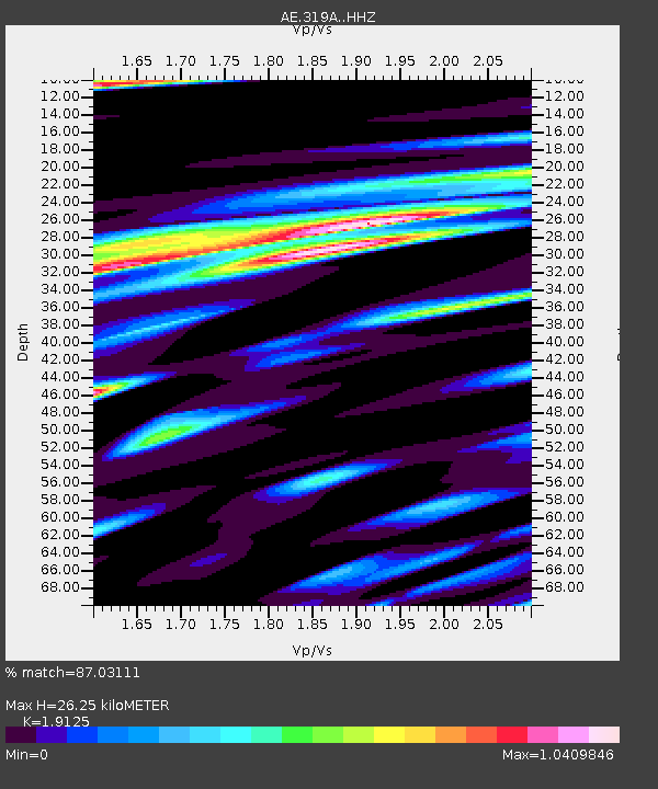
| Estimated Moho Depth: |
26.25 km |
| Estimated Crust Vp/Vs: |
1.91 |
| Assumed Crust Vp: |
6.182 km/s |
| Estimated Crust Vs: |
3.233 km/s |
| Estimated Crust Poisson's Ratio: |
0.31 |
|
| Radial Match: |
87.03111 % |
| Radial Bump: |
399 |
| Transverse Match: |
74.866264 % |
| Transverse Bump: |
400 |
| SOD ConfigId: |
27527651 |
| Insert Time: |
2022-06-04 07:03:21.058 +0000 |
| GWidth: |
2.5 |
| Max Bumps: |
400 |
| Tol: |
0.001 |
|

Signal To Noise
| Channel | StoN | STA | LTA |
| AE:319A: :HHZ:20220521T07:11:05.489993Z | 10.10047 | 1.5858737E-6 | 1.570099E-7 |
| AE:319A: :HHN:20220521T07:11:05.489993Z | 3.9537668 | 8.311984E-7 | 2.102295E-7 |
| AE:319A: :HHE:20220521T07:11:05.489993Z | 1.629223 | 2.178225E-7 | 1.3369717E-7 |
| Arrivals |
| Ps | 4.0 SECOND |
| PpPs | 12 SECOND |
| PsPs/PpSs | 16 SECOND |


