You are here: Home > Network List > AE - Arizona Broadband Seismic Network Stations List
> Station 319A Douglas, AZ, USA > Earthquake Result Viewer
319A Douglas, AZ, USA - Earthquake Result Viewer
| Earthquake location: |
Off East Coast Of Kamchatka |
| Earthquake latitude/longitude: |
51.2/161.0 |
| Earthquake time(UTC): |
2022/07/29 (210) 23:05:43 GMT |
| Earthquake Depth: |
7.0 km |
| Earthquake Magnitude: |
5.6 Mww |
| Earthquake Catalog/Contributor: |
NEIC PDE/us |
|
| Network: |
AE Arizona Broadband Seismic Network |
| Station: |
319A Douglas, AZ, USA |
| Lat/Lon: |
31.38 N/109.28 W |
| Elevation: |
1187 m |
|
| Distance: |
66.1 deg |
| Az: |
69.296 deg |
| Baz: |
316.509 deg |
| Ray Param: |
0.057838235 |
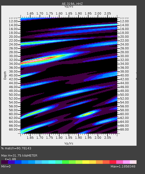
| Estimated Moho Depth: |
31.75 km |
| Estimated Crust Vp/Vs: |
1.69 |
| Assumed Crust Vp: |
6.182 km/s |
| Estimated Crust Vs: |
3.658 km/s |
| Estimated Crust Poisson's Ratio: |
0.23 |
|
| Radial Match: |
90.78143 % |
| Radial Bump: |
400 |
| Transverse Match: |
78.17885 % |
| Transverse Bump: |
400 |
| SOD ConfigId: |
28764291 |
| Insert Time: |
2022-08-12 23:07:39.369 +0000 |
| GWidth: |
2.5 |
| Max Bumps: |
400 |
| Tol: |
0.001 |
|

Signal To Noise
| Channel | StoN | STA | LTA |
| AE:319A: :HHZ:20220729T23:15:59.790003Z | 23.843512 | 1.0860306E-6 | 4.5548262E-8 |
| AE:319A: :HHN:20220729T23:15:59.790003Z | 7.155446 | 3.41199E-7 | 4.7683823E-8 |
| AE:319A: :HHE:20220729T23:15:59.790003Z | 6.628817 | 3.2501578E-7 | 4.903074E-8 |
| Arrivals |
| Ps | 3.7 SECOND |
| PpPs | 13 SECOND |
| PsPs/PpSs | 17 SECOND |


