You are here: Home > Network List > AE - Arizona Broadband Seismic Network Stations List
> Station 319A Douglas, AZ, USA > Earthquake Result Viewer
319A Douglas, AZ, USA - Earthquake Result Viewer
| Earthquake location: |
Sea Of Okhotsk |
| Earthquake latitude/longitude: |
49.8/145.1 |
| Earthquake time(UTC): |
2012/08/14 (227) 02:59:38 GMT |
| Earthquake Depth: |
583 km |
| Earthquake Magnitude: |
6.9 MB, 7.7 MW, 7.7 MW |
| Earthquake Catalog/Contributor: |
WHDF/NEIC |
|
| Network: |
AE Arizona Broadband Seismic Network |
| Station: |
319A Douglas, AZ, USA |
| Lat/Lon: |
31.38 N/109.28 W |
| Elevation: |
1187 m |
|
| Distance: |
75.8 deg |
| Az: |
58.156 deg |
| Baz: |
319.941 deg |
| Ray Param: |
0.04953647 |
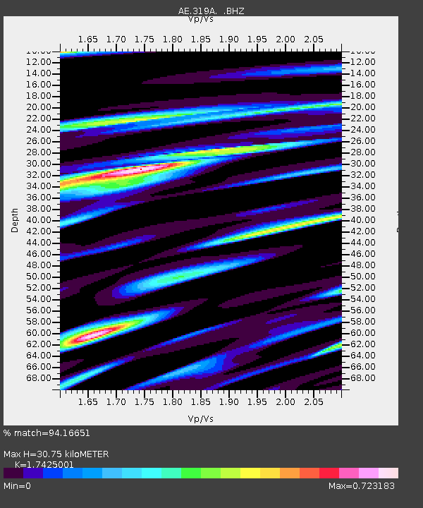
| Estimated Moho Depth: |
30.75 km |
| Estimated Crust Vp/Vs: |
1.74 |
| Assumed Crust Vp: |
6.182 km/s |
| Estimated Crust Vs: |
3.548 km/s |
| Estimated Crust Poisson's Ratio: |
0.25 |
|
| Radial Match: |
94.16651 % |
| Radial Bump: |
400 |
| Transverse Match: |
92.28001 % |
| Transverse Bump: |
400 |
| SOD ConfigId: |
469095 |
| Insert Time: |
2013-02-22 06:34:12.512 +0000 |
| GWidth: |
2.5 |
| Max Bumps: |
400 |
| Tol: |
0.001 |
|

Signal To Noise
| Channel | StoN | STA | LTA |
| AE:319A: :BHZ:20120814T03:09:54.475015Z | 58.22681 | 1.279707E-5 | 2.1977968E-7 |
| AE:319A: :BHN:20120814T03:09:54.475015Z | 35.80373 | 3.965281E-6 | 1.107505E-7 |
| AE:319A: :BHE:20120814T03:09:54.475015Z | 42.15002 | 4.320943E-6 | 1.02513425E-7 |
| Arrivals |
| Ps | 3.8 SECOND |
| PpPs | 13 SECOND |
| PsPs/PpSs | 17 SECOND |


