You are here: Home > Network List > AE - Arizona Broadband Seismic Network Stations List
> Station 319A Douglas, AZ, USA > Earthquake Result Viewer
319A Douglas, AZ, USA - Earthquake Result Viewer
| Earthquake location: |
Solomon Islands |
| Earthquake latitude/longitude: |
-6.4/154.9 |
| Earthquake time(UTC): |
2013/10/16 (289) 10:30:58 GMT |
| Earthquake Depth: |
35 km |
| Earthquake Magnitude: |
6.8 MWW, 6.7 MWB, 6.8 MWW, 6.8 MWC, 7.1 MI |
| Earthquake Catalog/Contributor: |
NEIC PDE/NEIC COMCAT |
|
| Network: |
AE Arizona Broadband Seismic Network |
| Station: |
319A Douglas, AZ, USA |
| Lat/Lon: |
31.38 N/109.28 W |
| Elevation: |
1187 m |
|
| Distance: |
98.3 deg |
| Az: |
59.301 deg |
| Baz: |
267.483 deg |
| Ray Param: |
0.039942455 |
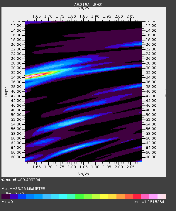
| Estimated Moho Depth: |
33.25 km |
| Estimated Crust Vp/Vs: |
1.63 |
| Assumed Crust Vp: |
6.182 km/s |
| Estimated Crust Vs: |
3.799 km/s |
| Estimated Crust Poisson's Ratio: |
0.20 |
|
| Radial Match: |
89.499794 % |
| Radial Bump: |
400 |
| Transverse Match: |
70.17875 % |
| Transverse Bump: |
400 |
| SOD ConfigId: |
626651 |
| Insert Time: |
2014-04-19 03:48:20.390 +0000 |
| GWidth: |
2.5 |
| Max Bumps: |
400 |
| Tol: |
0.001 |
|

Signal To Noise
| Channel | StoN | STA | LTA |
| AE:319A: :BHZ:20131016T10:44:00.724988Z | 3.3546689 | 4.8630443E-7 | 1.4496347E-7 |
| AE:319A: :BHN:20131016T10:44:00.724988Z | 1.6589259 | 1.524559E-7 | 9.190037E-8 |
| AE:319A: :BHE:20131016T10:44:00.724988Z | 1.8378931 | 1.7193342E-7 | 9.35492E-8 |
| Arrivals |
| Ps | 3.4 SECOND |
| PpPs | 14 SECOND |
| PsPs/PpSs | 17 SECOND |


