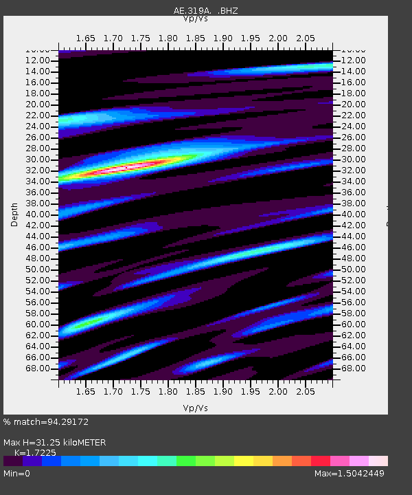
319A Douglas, AZ, USA - Earthquake Result Viewer

Earthquake location: Off East Coast Of Honshu, Japan
Earthquake latitude/longitude: 37.2/144.7
Earthquake time(UTC): 2013/10/25 (298) 17:10:19 GMT
Earthquake Depth: 35 km
Earthquake Magnitude: 7.1 MWW, 7.1 MWW, 7.1 MWB, 7.1 MWC, 7.2 MWC, 7.5 MI
Earthquake Catalog/Contributor: NEIC PDE/NEIC COMCAT
Network: AE Arizona Broadband Seismic Network
Station: 319A Douglas, AZ, USA
Lat/Lon: 31.38 N/109.28 W
Elevation: 1187 m
Distance: 83.0 deg
Az: 55.913 deg
Baz: 309.321 deg
Ray Param: 0.046477143
Estimated Moho Depth: 31.25 km
Estimated Crust Vp/Vs: 1.72
Assumed Crust Vp: 6.182 km/s
Estimated Crust Vs: 3.589 km/s
Estimated Crust Poisson's Ratio: 0.25
Radial Match: 94.29172 %
Radial Bump: 400
Transverse Match: 78.49943 %
Transverse Bump: 400
SOD ConfigId: 626651
Insert Time: 2014-04-19 05:34:44.664 +0000
GWidth: 2.5
Max Bumps: 400
Tol: 0.001

Signal To Noise

ChannelStoNSTALTA
AE:319A: :BHZ:20131025T17:22:09.975015Z26.1341763.5145129E-61.3447956E-7
AE:319A: :BHN:20131025T17:22:09.975015Z2.83419517.8914877E-72.7843842E-7
AE:319A: :BHE:20131025T17:22:09.975015Z5.23641351.0304889E-61.9679287E-7
Arrivals
Ps3.7 SECOND
PpPs13 SECOND
PsPs/PpSs17 SECOND