You are here: Home > Network List > AE - Arizona Broadband Seismic Network Stations List
> Station 319A Douglas, AZ, USA > Earthquake Result Viewer
319A Douglas, AZ, USA - Earthquake Result Viewer
| Earthquake location: |
Mendoza Province, Argentina |
| Earthquake latitude/longitude: |
-32.7/-67.1 |
| Earthquake time(UTC): |
2015/02/02 (033) 10:49:48 GMT |
| Earthquake Depth: |
172 km |
| Earthquake Magnitude: |
6.3 MO |
| Earthquake Catalog/Contributor: |
NEIC PDE/NEIC ALERT |
|
| Network: |
AE Arizona Broadband Seismic Network |
| Station: |
319A Douglas, AZ, USA |
| Lat/Lon: |
31.38 N/109.28 W |
| Elevation: |
1187 m |
|
| Distance: |
75.2 deg |
| Az: |
323.526 deg |
| Baz: |
144.133 deg |
| Ray Param: |
0.05137851 |
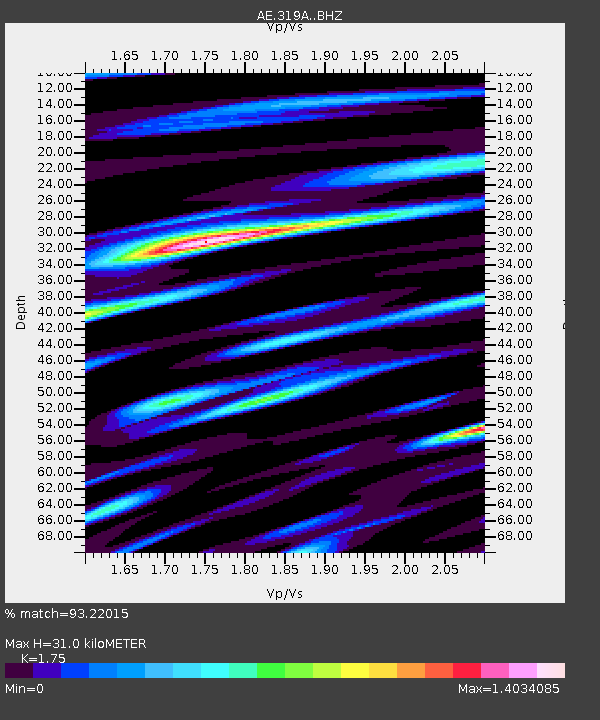
| Estimated Moho Depth: |
31.0 km |
| Estimated Crust Vp/Vs: |
1.75 |
| Assumed Crust Vp: |
6.182 km/s |
| Estimated Crust Vs: |
3.533 km/s |
| Estimated Crust Poisson's Ratio: |
0.26 |
|
| Radial Match: |
93.22015 % |
| Radial Bump: |
400 |
| Transverse Match: |
82.073616 % |
| Transverse Bump: |
400 |
| SOD ConfigId: |
6977071 |
| Insert Time: |
2019-04-16 10:49:19.450 +0000 |
| GWidth: |
2.5 |
| Max Bumps: |
400 |
| Tol: |
0.001 |
|

Signal To Noise
| Channel | StoN | STA | LTA |
| AE:319A: :BHZ:20150202T11:00:40.450Z | 27.011408 | 3.406828E-6 | 1.2612553E-7 |
| AE:319A: :BHN:20150202T11:00:40.450Z | 10.348004 | 1.3719872E-6 | 1.3258472E-7 |
| AE:319A: :BHE:20150202T11:00:40.450Z | 6.5439115 | 8.6275037E-7 | 1.3184017E-7 |
| Arrivals |
| Ps | 3.9 SECOND |
| PpPs | 13 SECOND |
| PsPs/PpSs | 17 SECOND |


