You are here: Home > Network List > AE - Arizona Broadband Seismic Network Stations List
> Station 319A Douglas, AZ, USA > Earthquake Result Viewer
319A Douglas, AZ, USA - Earthquake Result Viewer
| Earthquake location: |
Southeastern Alaska |
| Earthquake latitude/longitude: |
60.4/-140.3 |
| Earthquake time(UTC): |
2014/07/17 (198) 11:49:32 GMT |
| Earthquake Depth: |
0.6 km |
| Earthquake Magnitude: |
5.8 MI |
| Earthquake Catalog/Contributor: |
NEIC PDE/NEIC ALERT |
|
| Network: |
AE Arizona Broadband Seismic Network |
| Station: |
319A Douglas, AZ, USA |
| Lat/Lon: |
31.38 N/109.28 W |
| Elevation: |
1187 m |
|
| Distance: |
35.5 deg |
| Az: |
130.61 deg |
| Baz: |
333.832 deg |
| Ray Param: |
0.07718835 |
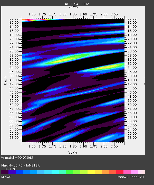
| Estimated Moho Depth: |
10.75 km |
| Estimated Crust Vp/Vs: |
1.60 |
| Assumed Crust Vp: |
6.182 km/s |
| Estimated Crust Vs: |
3.864 km/s |
| Estimated Crust Poisson's Ratio: |
0.18 |
|
| Radial Match: |
90.01062 % |
| Radial Bump: |
393 |
| Transverse Match: |
78.41507 % |
| Transverse Bump: |
388 |
| SOD ConfigId: |
751272 |
| Insert Time: |
2014-07-31 12:03:57.671 +0000 |
| GWidth: |
2.5 |
| Max Bumps: |
400 |
| Tol: |
0.001 |
|

Signal To Noise
| Channel | StoN | STA | LTA |
| AE:319A: :BHZ:20140717T11:55:59.825012Z | 14.717351 | 7.242075E-7 | 4.9207735E-8 |
| AE:319A: :BHN:20140717T11:55:59.825012Z | 4.5913444 | 2.8399603E-7 | 6.1854664E-8 |
| AE:319A: :BHE:20140717T11:55:59.825012Z | 1.5247985 | 1.5109939E-7 | 9.9094656E-8 |
| Arrivals |
| Ps | 1.1 SECOND |
| PpPs | 4.2 SECOND |
| PsPs/PpSs | 5.3 SECOND |


