You are here: Home > Network List > AE - Arizona Broadband Seismic Network Stations List
> Station 319A Douglas, AZ, USA > Earthquake Result Viewer
319A Douglas, AZ, USA - Earthquake Result Viewer
| Earthquake location: |
Easter Island Region |
| Earthquake latitude/longitude: |
-31.8/-111.2 |
| Earthquake time(UTC): |
2014/11/01 (305) 10:59:55 GMT |
| Earthquake Depth: |
10 km |
| Earthquake Magnitude: |
6.0 MWP |
| Earthquake Catalog/Contributor: |
NEIC PDE/NEIC COMCAT |
|
| Network: |
AE Arizona Broadband Seismic Network |
| Station: |
319A Douglas, AZ, USA |
| Lat/Lon: |
31.38 N/109.28 W |
| Elevation: |
1187 m |
|
| Distance: |
62.9 deg |
| Az: |
1.825 deg |
| Baz: |
181.816 deg |
| Ray Param: |
0.059937697 |
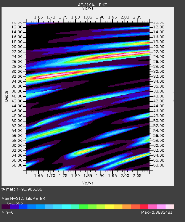
| Estimated Moho Depth: |
31.5 km |
| Estimated Crust Vp/Vs: |
1.70 |
| Assumed Crust Vp: |
6.182 km/s |
| Estimated Crust Vs: |
3.647 km/s |
| Estimated Crust Poisson's Ratio: |
0.23 |
|
| Radial Match: |
91.906166 % |
| Radial Bump: |
400 |
| Transverse Match: |
78.03482 % |
| Transverse Bump: |
400 |
| SOD ConfigId: |
813215 |
| Insert Time: |
2014-11-15 11:07:00.966 +0000 |
| GWidth: |
2.5 |
| Max Bumps: |
400 |
| Tol: |
0.001 |
|

Signal To Noise
| Channel | StoN | STA | LTA |
| AE:319A: :BHZ:20141101T11:09:50.34999Z | 11.984075 | 1.8294372E-6 | 1.5265569E-7 |
| AE:319A: :BHN:20141101T11:09:50.34999Z | 5.6232076 | 9.4188226E-7 | 1.6749912E-7 |
| AE:319A: :BHE:20141101T11:09:50.34999Z | 1.991393 | 2.2528111E-7 | 1.131274E-7 |
| Arrivals |
| Ps | 3.7 SECOND |
| PpPs | 13 SECOND |
| PsPs/PpSs | 17 SECOND |


