You are here: Home > Network List > AE - Arizona Broadband Seismic Network Stations List
> Station 319A Douglas, AZ, USA > Earthquake Result Viewer
319A Douglas, AZ, USA - Earthquake Result Viewer
| Earthquake location: |
Fiji Islands Region |
| Earthquake latitude/longitude: |
-19.7/-177.7 |
| Earthquake time(UTC): |
2014/11/01 (305) 18:57:22 GMT |
| Earthquake Depth: |
434 km |
| Earthquake Magnitude: |
7.1 MWW, 6.9 MI, 7.1 MWC, 7.2 MWB |
| Earthquake Catalog/Contributor: |
NEIC PDE/NEIC COMCAT |
|
| Network: |
AE Arizona Broadband Seismic Network |
| Station: |
319A Douglas, AZ, USA |
| Lat/Lon: |
31.38 N/109.28 W |
| Elevation: |
1187 m |
|
| Distance: |
83.0 deg |
| Az: |
53.279 deg |
| Baz: |
242.004 deg |
| Ray Param: |
0.045324933 |
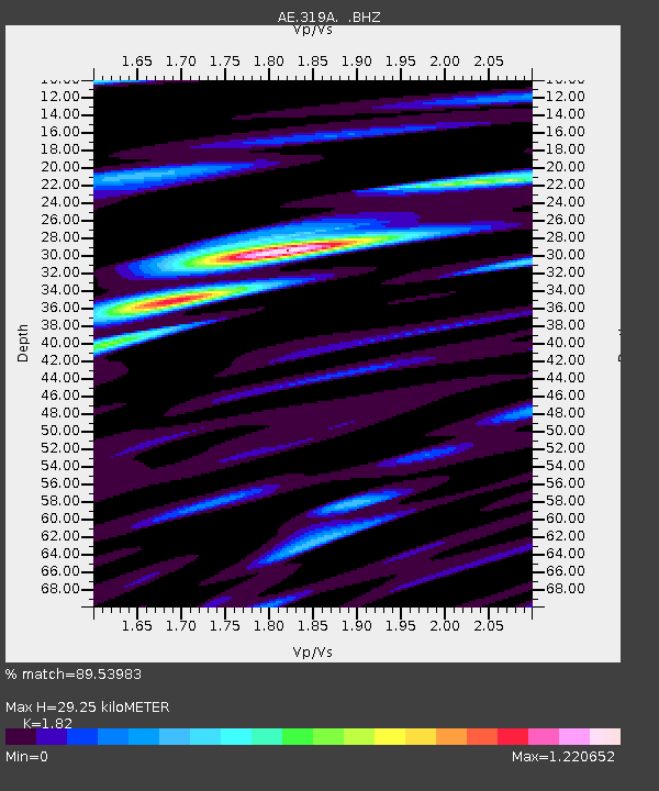
| Estimated Moho Depth: |
29.25 km |
| Estimated Crust Vp/Vs: |
1.82 |
| Assumed Crust Vp: |
6.182 km/s |
| Estimated Crust Vs: |
3.397 km/s |
| Estimated Crust Poisson's Ratio: |
0.28 |
|
| Radial Match: |
89.53983 % |
| Radial Bump: |
400 |
| Transverse Match: |
83.436646 % |
| Transverse Bump: |
400 |
| SOD ConfigId: |
813215 |
| Insert Time: |
2014-11-15 19:05:10.434 +0000 |
| GWidth: |
2.5 |
| Max Bumps: |
400 |
| Tol: |
0.001 |
|

Signal To Noise
| Channel | StoN | STA | LTA |
| AE:319A: :BHZ:20141101T19:08:29.275015Z | 9.218446 | 1.4294824E-6 | 1.5506761E-7 |
| AE:319A: :BHN:20141101T19:08:29.275015Z | 1.602017 | 2.2004684E-7 | 1.3735612E-7 |
| AE:319A: :BHE:20141101T19:08:29.275015Z | 1.7945584 | 2.8771152E-7 | 1.603244E-7 |
| Arrivals |
| Ps | 4.0 SECOND |
| PpPs | 13 SECOND |
| PsPs/PpSs | 17 SECOND |


